
Climate Change Adaptation: disused coal tips in Wales
An analysis of climate change adaptation in Wales, with a focus on the implications for disused coal tips.
In this page
Executive Summary
This report, commissioned and funded by the Welsh Government and produced by the Mining Remediation Authority provides an analysis of climate change adaptation in Wales, with a focus on the implications for disused coal tips. It outlines the scientific basis of climate change, distinguishing between mitigation and adaptation, and emphasises the importance of proactive management practices. The UK and Welsh governments have developed a robust legislative and policy framework, including the Climate Change Act 2008, Net Zero strategies, and the Environment (Wales) Act 2016, to address escalating climate risks.
The document highlights the increasing frequency and intensity of climate hazards, such as extreme rainfall, droughts, and heatwaves, and their potential to impact coal tip slope stability and future management implications. It presents meteorological data, climate projections (UKCP18), and risk assessments (CCRA3), demonstrating that Wales is particularly vulnerable due to its geography and legacy mining infrastructure.
An examination of coal tip ownership, management, and monitoring reveals a potential absence of climate change considerations and inconsistencies in climate related data acquisition, especially among privately owned sites. The report references the Disused Mine and Quarry Tips (Wales) Act 2025 and the establishment of a Disused Tips Authority for Wales to centralise governance and ensure uniform safety standards. It also explores the role of land use, instrumentation, and adaptive capacity in enhancing slope safety.
The report concludes with a series of practical recommendations, including improved data collection, climate-sensitive inspection protocols, and the integration of climate considerations into funding applications and management plans. It promotes a dual planning approach—preparing for a 2°C rise while considering the possibility of 4°C rise—and encourages the adoption of both soft and hard adaptation measures. Opportunities for co-benefits such as biodiversity enhancement and sustainable land use are also identified.
1.0 Introduction to climate change and climate adaptation
Human-induced climate change refers to the long-term alteration of global or regional climate patterns caused by human activities, primarily the emission of greenhouse gases such as carbon dioxide, methane, and nitrous oxide. These emissions result from burning fossil fuels, deforestation, industrial processes, and agriculture. In the UK, mitigation which involves reducing emissions to limit future warming, and adaptation, which focuses on adjusting to the impacts already underway are both crucial [1]. The UK faces rising sea levels, more frequent extreme weather events, and threats to biodiversity and infrastructure. Effective mitigation and adaptation strategies are essential to protect communities, ensure food and water security, and build a resilient economy in the face of a changing climate[2].
Adaptation to climate change is needed, as its impacts are already being felt and are projected to intensify, even under scenarios of significant reductions in greenhouse gas emissions. Proactive investment in climate resilience is therefore essential. Adaptation often requires upfront costs, but these are substantially lower than the long-term economic, social, and environmental costs of inaction[3].
Climate change is expected to increase the frequency of landslides in the UK due to more intense rainfall and prolonged periods of wet weather[4]. Landslides, defined as a type of mass movement involving the downward and outward displacement of material relative to the slope, occur under the force of gravity and can be triggered by various mechanisms[4] and include the failure of manmade coal tips.
These events can have serious consequences, including physical injuries and fatalities, negative impacts on mental wellbeing, economic costs related to repair and recovery, and disruption of access to essential services[5]. A 2024 assessment of colliery spoil tip failures further highlights that both extreme single-day precipitation and cumulative rainfall can act as triggers for landslides[6].
Wales has a significant number of disused coal tips, particularly concentrated in the South Wales Valleys, where the legacy of coal mining has left behind complex land management challenges. Coal tips can be associated with instability, particularly in time of heavy rain. A review of historic coal tip failures showed a strong connection between incidents and average rainfall[4]. These sites, often located close to residential communities, have come under renewed scrutiny due to the increasing risks posed by climate change. The landslides at Tylorstown[7] and Wattstown in 2020, triggered by heavy rainfall, served as a stark reminder of the potential hazards associated with these tips and highlighted the need for a more proactive and coordinated approach to their management. The Tylerstown event, saw 60,000 tonnes of debris slide into the Rhondda Fach River after several days of heavy rain associated with Storm Dennis.
2.0 Introduction to disused coal tips
Disused coal tips are man-made hills or mounds formed from the waste material, sometimes referred to as spoil, left over after coal mining operations. These tips are typically made up of rock, shale, and other non-coal materials that were separated from the coal during processing. Some tips may contain a significant amount of coal. The Welsh Government has an established policy to bring a managed end to the extraction and use of fossil fuels. It has a strong presumption against the granting of licences for any new abstraction including that from disused coal tips[8].
When coal mines close, the tips are often abandoned, hence the term ‘disused’. They are found near former coal mines, especially in historically coal-rich regions like South Wales, northern England, and parts of the U.S. and Europe. They can range in size and appearance. Some tips contain several million cubic metres of spoil and are very prominent in the landscape, whilst others are barely discernible. Many tips have been re-profiled since their initial creation and have had their slope angle altered and engineering features added to aid stability. It is common to have tips feature a series of berms and batters – slopes and plateaus. Tips that have been modified since their formation are known by several terms including reclaimed, restored and managed.
Until recently, the principal legislation relating to the stability and safety of coal tips in the UK is the Mines & Quarries (Tips) Act 1969 and (Tips) Regulations 1971 which were implemented following the Aberfan disaster in 1966. These were amended by the Quarries Regulation 1999 and the Mines Regulations 2014. The legislation primarily relates to tips at working mines and does not impose specific statutory provisions for regular inspections of disused tips. It does however provide local authorities with permissive powers to inspect and take action at disused tip sites to prevent danger to the public.
2.1 Tip ownership and management
There are over 2500 disused coal tips in Wales[9] and many of them are located near to residential properties, other buildings and infrastructure. The close siting of residential populations can be attributed to the historical development of mining communities in immediate proximity to operational coal mines. After the mines stopped producing coal, many former industrial sites were redeveloped to provide additional housing stock.
The ownership and land use of disused coal tips in Wales are highly variable, contributing to inconsistencies in their management and maintenance. While a significant proportion of these sites are the responsibility of local authorities and Natural Resources Wales (NRW), several hundred remain in private, and/or multiple ownership. This diversity in ownership has led to a wide range of land uses, from unmanaged woodland scrub and recreational development to continued industrial or agricultural use. Prior to the Tylorstown landslide in 2020 the fragmented ownership resulted in disparities in maintenance standards, with publicly owned tips generally subject to more systematic monitoring and upkeep, while privately owned sites typically lacked consistent oversight.
These variations posed challenges for the implementation of uniform safety protocols and highlighted the need for a centralised regulatory framework to ensure that all disused tips, regardless of ownership, are managed to a consistent and safe standard.
2.2 Disused coal tips and Welsh Government
The monitoring and management of disused coal tips in Wales have become an important component of the Welsh Government’s broader climate resilience and public safety agenda. In 2024, The Climate Adaptation Strategy for Wales was published, outlining over 240 cross governmental actions[10]. Following the event at Tylorstown, the oversight of coal tip safety has been significantly strengthened[11]. As of 2025, this responsibility is shared with several other key bodies, including local authorities, NRW and the Mining Remediation Authority, with strategic direction and funding provided by the Welsh Government. Coal tips are grouped into risk categories D to A, with higher rated sites (Category D) subject to biannual inspections, while lower category sites are monitored less frequently. These inspections are undertaken by qualified personnel from the Mining Remediation Authority.
The Welsh Government has proposed the establishment of a dedicated Disused Tips Authority for Wales under the Disused Mine and Quarry Tips (Wales) Act[12]. This new body will centralise oversight, maintain a national register of tips, and ensure consistent safety standards across regions. These developments reflect a proactive and evolving approach to managing legacy mining infrastructure in the context of contemporary environmental challenges, and follow recommendations from the Law Commission’s 2022 report on coal tip safety in Wales[13].
A summary of relevant climate change legislation for Wales and UK can be found in Appendix A.
3.0 Welsh climate
The UK Met office produce an annual report on the state of the UK climate. This report is usually published in July covering the data from the previous year. The latest report for 2024 highlights how baselines are shifting and temperature and rainfall extremes are becoming the norm[14].
South Wales, where the majority of disused coal tips are located, experiences a temperate maritime climate. It is heavily influenced by its proximity to the Atlantic Ocean and the prevailing south-westerly winds. This results in mild temperatures year-round, with cool summers and relatively mild winters. One of the most defining weather features is the high level of rainfall, particularly in the upland areas such as Bannau Brycheiniog (formerly Brecon Beacons), due to orographic uplift, where moist air is forced to rise over the hills and mountains, cooling and condensing to form precipitation.
The presence of steep sided valleys and rugged hills create localised microclimates, where frost and fog pockets can be trapped in narrow valleys. In summer, localised thunderstorms can form due to surface heating and rising air. These storms can be intense but affect only a small area, leading to sharp contrasts in rainfall over short distances.
Coastal areas like Cardiff and Swansea tend to be milder and slightly drier, though still subject to frequent showers and overcast skies. Windy conditions are common, especially during autumn and winter, when Atlantic storms can bring strong gales and heavy rain. Snowfall is rare at lower elevations but more frequent in the hills during winter. Overall, the weather in South Wales is changeable and often cloudy, with a strong maritime influence shaping its day-to-day variability[15].
Studies have shown the link between the distribution of coal tip failures and average annual rainfall[16]. Of all climate parameters, future rainfall is the most critical when assessing risks and managing disused coal tips. For further information on the two primary types of rainfall and their relevance to Wales, see Appendix B.
3.1 Meteorological Data in Wales
Both the Met office and NRW collect meteorological data from a number of weather stations in Wales. The recent data from these stations is available from the respective websites and historic values can be assessed by looking at the Centre for Environmental Data Analysis (CEDA) catalogue. CEDA catalogue is an online platform that allows users to search, explore, and access an archive of environmental data[17].
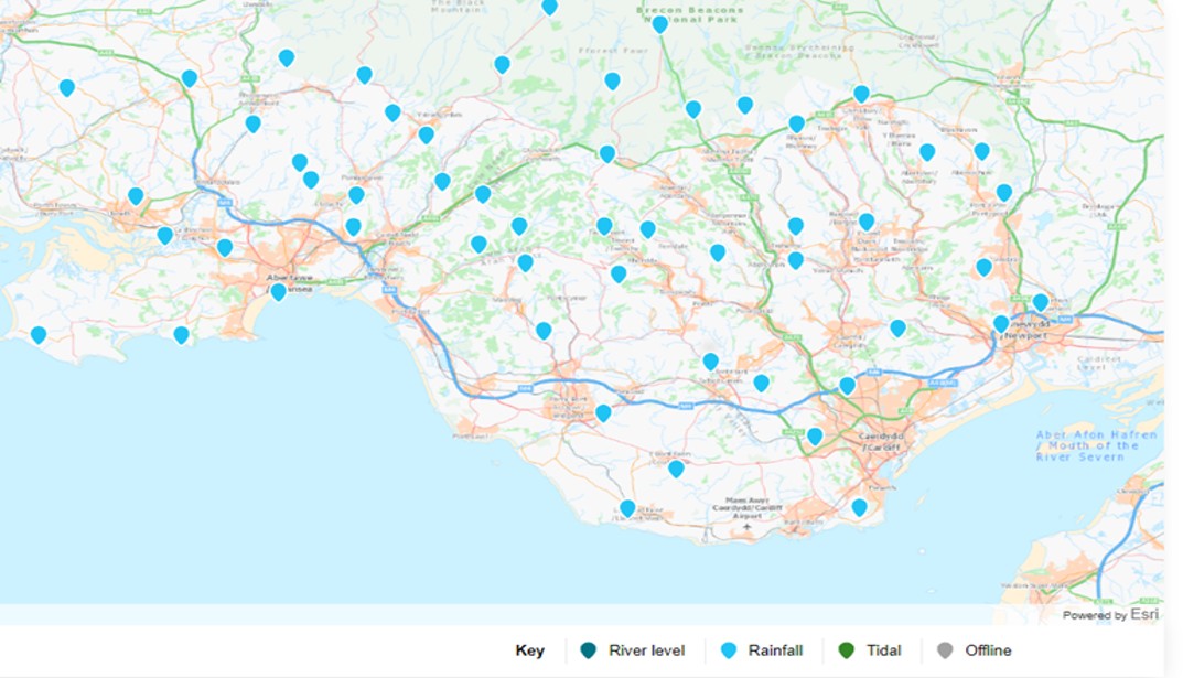
The table below highlights how rainfall measurements recorded by NRW gauges can vary significantly over relatively short distances. These readings are from the day in 2020 when the landslide occurred in Tylorstown. Unlike temperature, which tends to be more uniform, rainfall can be highly localised—even within a span of just 15 miles.
| Location | Distance from Tylorstown (miles) | Rainfall on 16/02/2020 (mm) |
|---|---|---|
| Maerdy | 3 | 132 |
| Nant Yr Isfa | 1.5 | 125 |
| Blaenogwr | 4.5 | 68
|
| Cardiff St Fagans | 14 | 28 |
Some disused coal tips in Wales are equipped with rain gauges, however there is currently no comprehensive assessment of the collected data or analysis of tip performance in relation to rainfall events.
1. Recommendation
Collaborate with external organisations to obtain and share local rain gauge data for the purposes of assessing climate change risks and impacts.
Purpose
Many organisations operate their own rain gauges, which are particularly valuable for monitoring and reviewing extreme weather events, especially when combined with radar imagery of rainfall.
Action
Welsh Government Coal Tip Safety Task Force /agent
4.0 Climate Risk Assessment in Wales
Climate Change Risk Assessment 3 (CCRA3), published in 2021, is a statutory assessment under the UK Climate Change Act 2008, conducted every five years to evaluate climate-related risks and opportunities. It identifies 61 key risks across sectors such as infrastructure, health, agriculture, biodiversity, and the built environment. The assessment serves as a vital evidence base for shaping the UK’s National Adaptation Programme (NAP) and guiding policy, investment, and resilience efforts. CCRA3 emphasises the growing urgency of climate adaptation, warning that many risks have intensified and that delayed action could lead to escalating costs and irreversible impacts.
Disused coal tips in Wales are not listed as a standalone risk among the 61 identified climate risks and opportunities. However, they are explicitly referenced under broader categories relating to land stability, infrastructure and the natural environment. This is a change from the previous document, CCRA2, which did not contain specific reference to tips. Each of the categories that mentions coal tips have been assigned an urgency score requiring either ‘further investigation’ or ‘more action’ [19],[20]. The relevant sections in the Technical Report look at the current and future levels of risk across different sectors and signpost to related research and adaptation progress.
| CCRA3 Risk ID | Receptor | Description |
|---|---|---|
| Infrastructure I5 | Transport Networks | Slope and embankment failure |
| Infrastructure I7 | Subterranean and surface infrastructure | Subsidence |
| Natural Environment N4 | Soils | Changing climatic conditions, including seasonal aridity and wetness |
| Health, Communities and Built Environment H5 | Building fabric | Moisture, wind and driving rain |
The table above shows the four areas where specific mention of tips is made.
The Climate Change Committee has been critical of the adaptation progress made by the majority of UK sectors since 2021. In a 2025 statement, its adaption committee chair Baroness Brown commented that “The next CCRA must ensure that the evidence base continues to evolve to serve the changing needs of adaptation policy, including the critical shift towards a focus on delivery and implementation of adaptation”[21].
The next CCRA report, due for publication in 2026 will rationalise the 61 risks down to 45 and will move away from sector specific risks, focusing more on fewer, priority outcomes[22].
5.0 Future Welsh climate
The scientific community are generally agreed that even with mitigation measures in place, the UK climate will change. It is believed that summers will become hotter and drier and that winters will be milder and wetter. The following table with a summary for Wales is from data obtained using the UK Climate Projections 2018 (UKCP18) climate model[23] and shows temperature, rainfall and sea level rise under different emission scenarios.
| 2050s RCP2.6 (50th percentile) | 2050s RCP6.0 (50th percentile) | 2080s RCP2.6 (50th percentile) | 2080s RCP6.0 (50th percentile) | |
|---|---|---|---|---|
| Annual Temperature | +1.2°C | +1.1°C | +1.3°C | +2.3°C |
| Summer Rainfall | -15% | -15% | -18% | -26% |
| Winter Rainfall | +6% | +5% | +7% | +13% |
| Sea level rise (Cardiff) | 22 cm | 28 cm* | 43 cm | 76 cm* |
Source: Evidence for the third UK Climate Change Risk Assessment (CCRA3) Summary for Wales, 2021
UKCP18 provides high-resolution climate projections for the UK, helping planners assess future climate parameters. It supports adaptation strategies and is used by government and researchers. For more detail on UKCP18, including some limitations of its application see Appendix D.
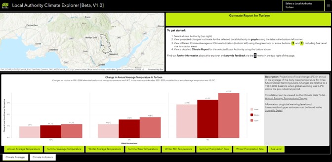
As one of the expected effects of climate change is a deterioration of slope conditions4 it is important to understand the potential changes to climate in the various areas of Wales that contain disused coal tips. The Local Authority Climate Explorer offers one of the most accessible platforms for examining future climate projections for Wales. This service uses Met Office UKCP18 data presented in a dashboard setting for each Local Authority in the UK and is part of a suite of products available as the Local Authority Climate Service (LACS) [24].
Since Welsh local authorities are quite small (with the exception of Powys) and often follow the natural landscape features that can influence the weather, these dashboards produce very useful projections. At present, a dedicated tab providing projections of future rainfall extremes at the Local Authority level is not available. A request has been submitted to the Met Office, recommending the inclusion of this feature in future updates. If a pilot area is to be selected, the central and eastern valleys of the South Wales coalfield should be prioritised, as this region has the strongest historical association with coal tip failures[15]. However, it should be noted that the study underpinning this association is dated and focused on active tips, rather than disused ones.
In addition to providing future projections relative to a baseline for various climate parameters, it features a facility to generate a ‘Climate Report’ creating a useful summary of each Local Authority area. Another useful tool, not available yet for every conurbation is the ‘City Pack’, which provide an excellent summary of climate change projections and baseline data for some UK cities, including Cardiff[23].
5.1 Rainfall in the future
With climate change, convective rainfall is expected to increase more significantly than other types of precipitation. This is because warmer temperatures increase both evaporation and the atmosphere’s ability to hold moisture, leading to more frequent and intense convective storms. For every 1°C increase in air temperature, the atmosphere can hold 7% more water[26]. Frontal rainfall may also intensify, particularly in mid-latitude areas, which includes all of Wales.
The table below shows the baseline variability across the Local Authority areas in Wales, and the projected increases under 2°C and 4°C warming scenarios. The highlighted cells show the variation between Welsh Local Authority baseline precipitation and the projected increase in a 4°C warming scenario. The current lowest winter baseline precipitation value is 2.33mm in Flintshire, this is projected to be as high as 21mm in a 4° warmer world. Similar, a Rhondda Cynon Taf baseline of 6.84mm could increase to 37mm daily average in a warmer world. These figures show average figures. It is important to recognise that it is ‘non average’ events that are likely to have an impact on disused tip behaviour. For further information on extreme projections see Appendix D.
| Local Authority containing a registered disused coal tip | 1981-2000 winter precipitation baseline mm (daily average) | 2°C Global warming scenario % increase median | 2°C Global warming scenario % increase median | 4°C Global warming scenario % increase median | 4°C Global warming scenario % increase upper |
|---|---|---|---|---|---|
| Blaenau Gwent | 5.63 | 9 | 14 | 19 | 25 |
| Bridgend | 5.43 | 12 | 16 | 26 | 36 |
| Caerphilly | 5.32 | 12 | 15 | 25 | 30 |
| Cardiff | 4.19 | 9 | 15 | 25 | 37 |
| Carmarthenshire | 5.23 | 10 | 15 | 22 | 30 |
| Flintshire | 2.33 | 5 | 12 | 14 | 21 |
| Isle of Anglesey | 3.24 | 6 | 12 | 16 | 29 |
| Merthyr Tydfil | 6.48 | 10 | 16 | 20 | 29 |
| Monmouthshire | 3.56 | 11 | 15 | 22 | 28 |
| Neath Port Talbot | 6.01 | 11 | 17 | 25 | 31 |
| Pembrokeshire | 4.18 | 9 | 15 | 21 | 33 |
| Powys | 4.99 | 7 | 11 | 14 | 18 |
| Rhondda Cynon Taf | 6.84 | 12 | 16 | 25 | 31 |
| Swansea | 4.45 | 10 | 16 | 27 | 37 |
| Torfaen | 4.71 | 11 | 15 | 24 | 28 |
| Wrexham | 2.7 | 7 | 14 | 17 | 18 |
| Average | 4.7 | 9.4 | 14.6 | 21.4 | 28.8 |
5.2 Cut-off lows
A cut-off low is a type of weather system that forms when a low-pressure area becomes detached from the main jet stream in the upper atmosphere. This detachment isolates the system, allowing it to drift slowly or even stall over a region. Cut-off lows are typically cold-core weather systems and are most common in the mid-latitudes, including parts of Europe and the UK[27].
When a cut-off low lingers over an area, it can bring several days of heavy rainfall, thunderstorms, flooding, and cooler-than-average temperatures. The deadly floods that struck Valencia, Spain in 2024 were caused by this type of weather system. They expected to become more common in a warming world[28].
It is difficult to predict cut-offs lows especially in the longer term. Climate models are not able to show where these might occur and it is advisable to utilise advances in more short-term weather forecasts and ‘nowcasting’[29].
2. Recommendation
It is recommended that the Met Office be commissioned to analyse daily peak rainfall data from a geographically small Welsh Local Authority. This analysis would involve reviewing existing records and applying an uplift factor to estimate the potential magnitude of extreme daily rainfall under future climate scenarios.
Purpose
This would effectively create an ‘extreme rainfall’ tab within the LCAS dashboard, enabling users to compare historic extreme rainfall events with projections under future climate scenarios. The trial could serve as a pilot to assess the value of expanding this approach to other local authorities.
Action
Welsh Government Coal Tip Safety Task Force/ Agent
6.0 Climate change hazards
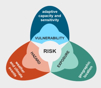
In the context of climate risk, the concepts of hazard, exposure, and vulnerability are fundamental to understanding potential impacts. A hazard refers to a potentially damaging physical event or trend, such as a heatwave, flood, or drought. Exposure describes the presence of people, infrastructure, ecosystems, or assets in areas that could be adversely affected by these hazards. Vulnerability is the degree to which those exposed elements are susceptible to harm, influenced by factors such as sensitivity, adaptive capacity, and socio-economic conditions.
Together, these three elements determine the overall risk: even a moderate hazard can have severe consequences if exposure and vulnerability are significant.
Hazards are considered to be either chronic or acute. Chronic climate change hazards are long-term, gradual changes in climate patterns that can cause persistent stress on natural and human systems. Chronic hazards develop slowly over time and can be damaging, especially when left unaddressed. An acute climate change hazard refers to a sudden, severe, and often short-term event caused or intensified by climate change. These risks can lead to immediate and significant impacts on people, infrastructure, ecosystems, and economies. The table below shows the main climate hazards relating to disused tips in Wales.
| Hazard Type | Hazard | Description |
|---|---|---|
| Chronic | Rising Temperatures | Long-term warming trends |
| Chronic | Changing rainfall patterns | Persistent droughts or shifts in seasonal rainfall |
| Acute | Heatwaves | Sudden spikes in temperature |
| Acute | Floods | Intense rainfall or storm surges that overwhelm drainage systems and rivers |
| Acute | Hurricanes and cyclones | Powerful storm systems that form over warm oceans |
| Acute | Wildfires | Rapidly spreading fires fuelled by heat and drought |
The Intergovernmental Panel on Climate Change (IPCC) consider how that the variables of risk are linked and how the outcomes can be influenced by additional factors[30]. It is important to recognise that just as there is variability between disused tips, the context in which they are located will also vary, meaning no two sites will face the same combination of risks.
6.1 Hazards with respect to slope stability
Projected changes in climate hazards under future emissions scenarios are evaluated in relation to the specific components assessed during routine inspections of disused coal tips.
The table below outlines which structural or environmental elements of the tip may be affected by each climate variable. Each identified climate-related hazard is subsequently analysed with respect to its potential influence on disused tip management.
| Climate Hazard | Geotechnical | Land Use | Engineering Infrastructure | Drainage | Instrumentation and Monitoring | Access and other |
|---|---|---|---|---|---|---|
| Wetter winters | * | * | * | * | ||
| Extreme rainfall events | * | * | * | * | * | |
| Droughts / low rainfall | * | * | ||||
| High winds | * | * | * | * | * | * |
| Heatwaves | * | * | * | * | ||
| Rising Sea Level | ||||||
| Hotter summers | * | * | * | * | * | |
| Low Temperatures | * | |||||
| Lightning / electrical storms | * | * |
6.1.1 Wetter winters
Studies suggested that both extreme single-day precipitation and accumulative precipitation can trigger landslides on colliery spoil tips[6]. Prolonged rainfall can significantly increase the risk of slope instability through several interconnected processes. As rainwater infiltrates the ground, it becomes saturated, raising pore water pressure and reducing the friction that holds particles together, making it easier for the material to slide. In clay-rich spoils, such as disused tips containing mudstones, water absorption causes particles to swell and lose cohesion, weakening the structure. Additionally, the added weight of water increases the gravitational force on slopes, especially those already unstable. Vegetation, which normally stabilises slopes, can also be compromised as roots weaken or rot under persistent wet conditions. During colder months, freeze-thaw cycles further exacerbate instability by expanding cracks in the tip during freezing, then loosening material upon thawing—particularly dangerous when the ground is already saturated. These combined effects make slopes more vulnerable to failure during and after heavy rainfall.
Rainfall may fall directly onto the tip or flow towards it from adjacent land. It is important to consider runoff from nearby or upslope areas, as changes in land management can significantly increase the volume of water reaching the tip[31].
If the water table rises above the land surface in a new location, or if erosion, construction or seismic activity opens new pathways, new springs can form. These can be temporary or permanent if the groundwater supply remains steady. Although the UK experiences low to moderate seismic activity, areas such as northwest and south Wales have recorded some of the largest British earthquakes, with magnitudes exceeding 5ML[32]. While these events are generally not considered significant in relation to landslide risk, they should not be entirely disregarded as the locations of disused tips coincide with higher UK seismicity.
New springs, or re-activated historic springs, can create slope instability, particularly in upland terrain, due to several interacting mechanisms. When groundwater emerges as a spring, it saturates the surrounding soil, increasing pore water pressure and reducing the shear strength of slope materials, making them more susceptible to sliding. Additionally, the flowing water can erode material, especially if concentrated in one area, which may undercut the slope and trigger localised failures or larger landslides[4]. The added water also increases the overall weight of the slope, enhancing downslope gravitational forces that can overcome weakened resisting forces like friction and cohesion. Furthermore, persistent wet conditions from new springs can alter vegetation cover, and the loss of deep-rooted plants due to waterlogging can reduce root reinforcement, further destabilising the slope. These combined effects make spring emergence a factor in slope stability assessments.
6.1.2 Extreme rainfall events
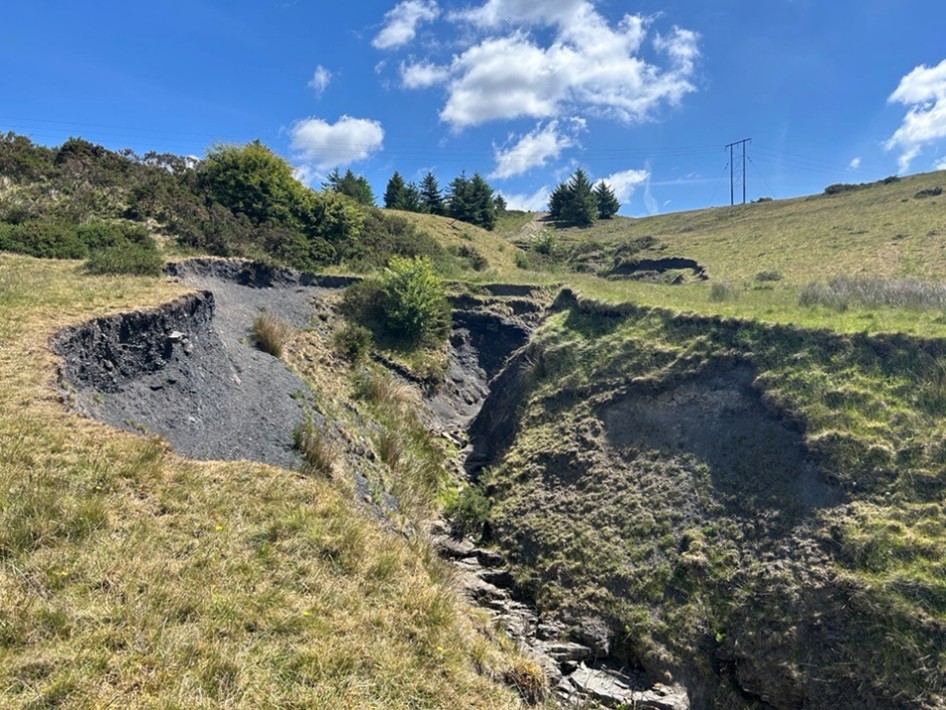
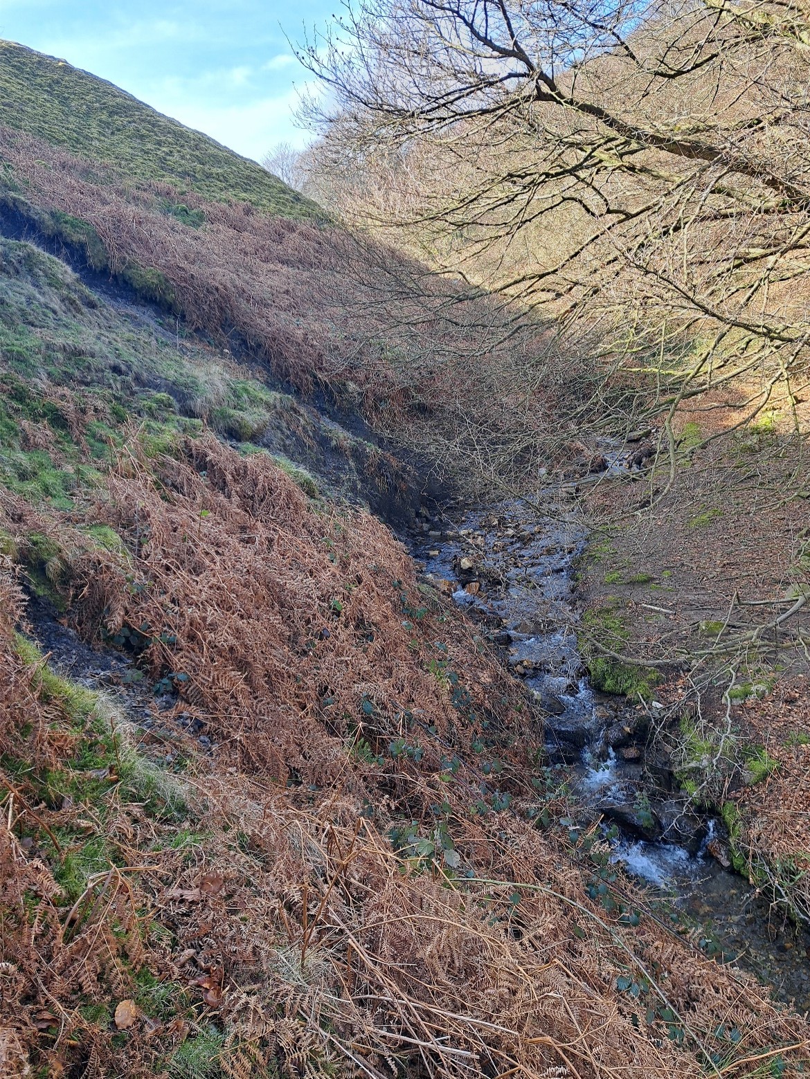
Like prolonged rainfall, extreme rainfall events greatly increase the risk of movement through a combination of physical processes. Rapid ground saturation occurs when heavy rain quickly fills the pore spaces, raising pore water pressure and reducing the friction that holds particles together. This leads to a loss of shear strength in the tip material, making it easier for gravity to trigger movement. Additionally, the added water increases the overall weight of the slope, enhancing the downslope gravitational force. Vegetation, which normally stabilises slopes, can be uprooted or weakened by saturated ground, especially in areas already affected by deforestation or fire. Furthermore, fast-moving surface water can erode the base of slopes or riverbanks, undercutting their support and initiating failure from below. The removal of material from the toe of a tip, or ‘de-buttressing’ has been described as the principal preventable cause of tip instability[31]. Heavy rainfall can overwhelm slope drainage systems leading to out-of-channel flow, surface erosion and washouts.
The British Geological Survey (BGS) is the UK’s leading authority on landslides, offering extensive research, monitoring, and risk assessment tools. Their work includes maintaining the National Landslide Database, analysing rainfall thresholds that may trigger landslides, and developing susceptibility models to identify at-risk areas. The following image shows UK landslides plotted against rainfall for the last 10 years[33] and shows landslides observations associated with rainfall.
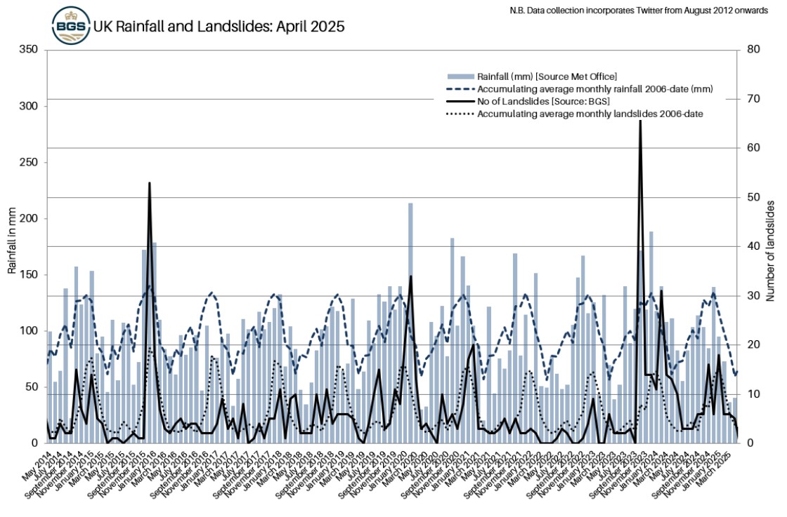
“UK Rainfall (source: MetOffice) and landslides (source: BGS) in the UK (April 2025). Reproduced with permission from the British Geological Survey © UKRI 2026 All Rights Reserved.
6.1.3 Drought
Drought or prolonged low rainfall can indirectly worsen tip stability, particularly when followed by intense rain. During dry periods, spoils with high clay content can shrink and crack, creating deep fissures that allow rainwater to rapidly infiltrate once precipitation returns, destabilising deeper spoil layers. The tip material itself can degrade, losing cohesion and becoming prone to uneven swelling or softening when re-wetted. Additionally, post-drought rainfall may initially run off hardened, hydrophobic surfaces, causing surface erosion and the creation of runnels, or it may infiltrate quickly through cracks saturating deeper layers. Bare, dry slopes are also more vulnerable to wind and water erosion, which can gradually undercut and destabilise them over time.
Prolonged drought weakens the vegetation growing on disused tips, making it more vulnerable to pests, diseases, fire and other environmental stressors. In younger or shallow-rooted species, drought can even cause dieback or death.
6.1.4 High winds
The scientific community has not reached a consensus on whether climate change is likely to result in an increase in the frequency or intensity of storms and high winds36.
High winds can increase slope instability, particularly when combined with other environmental stressors like saturated soils or drought[35]. One major factor is tree uprooting where strong winds can topple trees, especially when the ground is waterlogged or weakened, disturbing the soil and removing root systems that normally help stabilise slopes. In the context of disused tips, the void created by an uprooted tree could serve as a conduit for rainfall infiltration and animal intrusion, potentially exacerbating structural degradation. Additionally, wind damage can strip away vegetation or break branches, reducing both the protective canopy and the root reinforcement that help prevent erosion and water infiltration.
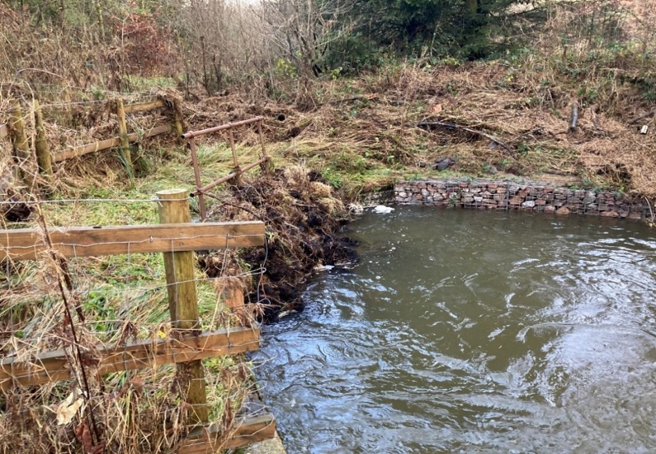
The drainage features on disused tips such as channels and culverts can become blocked with storm debris reducing their efficacy, potentially leading to out-of-channel flow if high winds are combined with rainfall.
6.1.5 Hotter summers and heatwaves
Hotter summers and an increased frequency of heatwaves can indirectly increase tip instability risk by drying and cracking soil, which allows rainwater to rapidly infiltrate and destabilise deeper layers. They also weaken or kill vegetation, reducing root strength and soil cohesion, making slopes more prone to erosion and failure when intense rainfall follows.
In tips with formal drainage or retaining features, exposure to extreme heat can damage concrete, leading to cracking, spalling and accelerated aging[36].
Heatwaves can lead to overheating in monitoring equipment, particularly when devices are not built for extreme temperatures or lack proper cooling and ventilation. Elevated ambient temperatures may cause sensors to malfunction or produce inaccurate readings, while electronic components such as batteries, processors, and power supplies are at increased risk of failure. It is important that devices used to monitor tips are properly maintained and calibrated to ensure reliable data collection[36]. It is worth noting that studies have shown a rise in antisocial behaviour during warmer weather conditions[43]. This includes increased incidences of arson and vandalism, which may present additional challenges for effective tip management.
6.1.5.1 Wildfires
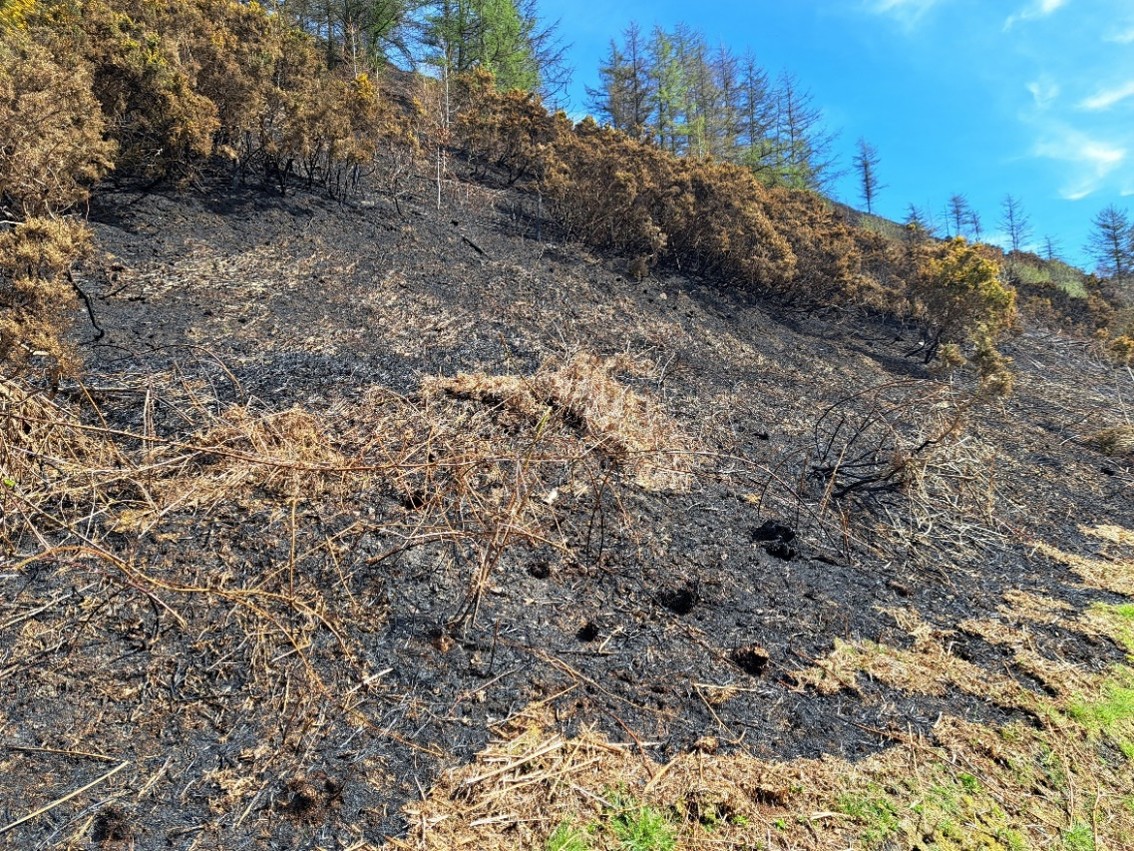
The Met Office concluded that fires are an emerging threat in the UK[38]. Wildfires can increase tip stability problems by destroying vegetation that stabilises slopes and limits infiltration[39]. They can also create hydrophobic soils that repel water leading to rapid run-off in subsequent rainfall events[4]. Watercourse pollution can occur following a wildfire on a disused coal tip, as rainfall flowing over or through exposed spoil may carry particles and contaminants into nearby water bodies[41].
Spontaneous combustion is another phenomenon associated with disused coal tips. Although the processes of self-heating and ignition are not fully understood [40], the conditions required to trigger such events are likely to occur more frequently in a warmer climate, and their incidence is expected to rise[41].
6.1.6 Sea level rise
Although sea level is likely to have a profound impact on coastal landscapes, it is not thought that this will impact on the portfolio of disused tips in Wales.
6.1.7 Colder Winters
Some climate researchers studying the Atlantic Meridional Overturning Circulation (AMOC) and the Subpolar Gyre suggest that shifts in these ocean systems could lead to a colder climate in parts of Europe, including the UK[44],[45]. This is an interesting perspective but this report aligns with broader scientific consensus that the UK is expected to experience a warmer future overall.
6.1.8 Lightning Storms
Climate change is expected to increase the frequency of lightning events[46]. While these may affect power supplies and site instrumentation, lightning is not considered a primary climate hazard of concern in relation to disused coal tips in Wales. In contrast, the increased rainfall associated with storm events, described above poses a significantly greater risk.
6.2 Compound Risks
Compound risks in the context of climate change refer to situations where multiple climate-related hazards or stressors occur simultaneously, sequentially, or interact in ways that amplify their overall impact. These risks are more complex and dangerous than individual hazards because they can overwhelm systems and reduce the effectiveness of standard responses. These include simultaneous hazards, such as a heatwave and drought occurring together. Cascading effects, where one event triggers another, like heavy rain causing a landslide that blocks a river and leads to downstream flooding; sequential events, where hazards occur in close succession, such as back-to-back storms leaving little time for recovery.
These compound risks are important to consider in the context of tip management, as the weather events that trigger instability may not occur in isolation. Under future climate scenarios, a slow-moving storm delivering intense rainfall could impact a tip already weakened by vegetation dieback and surface desiccation following a prolonged dry summer. This combination of factors may lead to blocked or overwhelmed drainage systems, localised flooding, erosion at the toe of the tip by nearby watercourses, and restricted site access—all of which could significantly compromise the stability and safety of the tip.
In many cases, the factors contributing to a tip’s vulnerability to current weather events and climate change are reflected in its assigned category. However, the initial classification was carried out through a desk exercise and did not explicitly take weather-related parameters into account.
7.0 Vulnerability assessment of tips in Wales
When assessing the risks posed by climate change, a common method involves examining past events and identifying the climate conditions that triggered them. For example, one might analyse the amount of snowfall that led to school closures and then evaluate how likely such conditions are under future climate scenarios.
This method is most effective when detailed operational records are available. In sectors like transport, it's relatively straightforward to quantify impacts—such as the number of bus journeys cancelled due to wind-related bridge closures or rail services disrupted by heavy rainfall. These records help link specific weather events to operational consequences. However, in the case of disused coal tips, such data is much harder to obtain. While there are records of reactive inspections following heavy rain, the full impact is poorly documented. One Local Authority noted that an additional 50 visits were undertaken following Storm Bert in November 2024 (personal communication). Public calls to local authorities regarding coal tips may be logged, but they are not typically linked to specific weather events. Similarly, site visits by operational staff are not routinely recorded as responses to weather, nor is the nature of any observed impact.
This lack of detailed, weather-linked data makes it difficult to determine the thresholds at which problems are noted, complicating efforts to predict how climate change might affect these sites in the future. For more information on climate change assessment methodology, see Appendix E.
3. Recommendation
Record all weather-related reactive maintenance tasks and report any near-miss incidents. Issue an annual questionnaire to tip owners to determine the type and extent of any activity. While a full response rate is not expected, even a limited number of replies would provide valuable insights.
Purpose
To identify patterns and trends linked to adverse weather events, and to facilitate the sharing of lessons learned across the sector, supporting continuous improvement.
Action
Welsh Government Coal Tip Safety Task Force or agent coordinate with tip owners
There have been three incidences in recent years where a known weather event has triggered a coal tip slope failure. These were Storm Dennis in February 2020, heavy rainfall in December 2020 and Storm Bert in November 2024 which caused landslides at coal tips in Tylorstown, Wattstown and Cwmtiliery respectively.
| Location | Weather Event | Recorded Rainfall at nearest NRW gauge in 24h | Impact |
|---|---|---|---|
| Tylorstown | Storm Dennis | 132 mm (Maerdy gauge) | Debris flow |
| Wattstown | Unnamed | 36 mm (Nant Yr Ysfa gauge) | Debris slide |
| Cwmtillery | Storm Bert | 59 mm (Cwmtillery gauge) | Debris slide |
The NRW rain gauge at Cwmtillery is located less than a mile from the site of the tip landslide in Cwmtillery village. Eyewitnesses reported intense rainfall in the village, suggesting that actual rainfall levels may have exceeded those recorded by the nearby gauge.
Due to the limited operational data available across the tips portfolio, it is challenging to predict which sites may face stability issues under future climate scenarios. Any potential failure is likely to result from a combination of interacting factors and the distinct characteristics unique to each site.
For the majority of disused coal tips, the threshold rainfall intensity that could cause slope instability is unknown. In practice, slope failure is typically governed by a complex interplay of hydrological, geotechnical, and morphological factors. Specific geomorphological and structural characteristics of the tips such as slope angle, material composition, compaction, and drainage conditions, can significantly amplify their susceptibility to weather induced failure mechanisms. The presence of legacy features such as tunnels and chambers may also present problems, as these voids within the tip might not be visible for inspection and may deteriorate over time.
4. Recommendation
Develop a checklist template to capture all tip characteristics that may be influenced by climate change. Use this checklist to assess each inspected tip, identifying those that exhibit multiple climate-sensitive features.
Purpose
To support consistent evaluations, highlight sites with compounded vulnerabilities, incorporate climate change impacts into disused tip management and inform prioritisation for further investigation or intervention.
Action
Disused Tips Authority for Wales / Welsh Government Coal Tip Safety Task Force with MRA
7.1 Vegetation and disused coal tips
Vegetation cover including forestry, can play a role in enhancing slope stability, particularly in areas prone to erosion or landslides such as coal tips. Plant roots reinforce the spoil structure by increasing its shear strength and anchoring it to deeper, more stable layers. Tree and shrub canopies also intercept rainfall, reducing the volume and speed of water reaching the tip surface, while evapotranspiration helps regulate spoil moisture levels. These combined effects reduce the likelihood of slope saturation and surface runoff, both of which are key triggers for slope failure[4].
However, climate change introduces several risks that could undermine these stabilising benefits. Increased rainfall intensity and frequency can exceed the buffering capacity of vegetated slopes, leading to rapid ground saturation and elevated pore water pressures. At the same time, prolonged droughts may weaken or kill vegetation, reducing root cohesion and increasing vulnerability to fires and erosion. Additionally, climate-driven shifts in species composition, pest outbreaks, and wildfire risks can all degrade vegetation health and reduce their effectiveness in stabilising slopes[48].
It should also be noted that unmanaged sites are likely to undergo gradual changes in response to shifting climate patterns. For example, increased waterlogging on a slope may lead to the emergence of Molinia tussocks, plants that thrive in damp conditions or other hydrophilic vegetation, indicating altered ground conditions over time. It is important that these subtle changes are noted and recorded during site inspections[4].
In summary, while vegetation cover is a valuable natural tool for slope stabilisation, its effectiveness is increasingly threatened by the impacts of climate change. Adaptive management strategies that consider changing climatic conditions and promote resilient vegetation cover will be essential to maintaining slope stability in the future[49]. The challenge will be how to select the right planting regime that suits the location and function and still permits thorough safety inspections.
7.2 Adaptive capacity
Adaptive capacity refers to the ability of individuals, communities, or systems to adjust to climate change impacts and reduce potential damage. Key components include knowledge and awareness, such as understanding local climate risks and having access to forecasts and education. Resources, including financial, technological, and human are essential for implementing adaptation measures like flood defences or early warning systems. Institutions and governance play a critical role through flexible policies and effective planning. Social capital, including community trust and networks, enhances collective resilience during crises. Lastly, infrastructure that is robust and climate-resilient—such as buildings, transport, and utilities can help reduce vulnerability and supports long-term adaptation.
5. Recommendation
Develop a comprehensive guide for tip owners that outlines key considerations, encourages best practice, highlights the implications of climate change, and clarifies legal responsibilities associated with tip ownership. It is recommended that the document includes references to appropriate organisations capable of providing professional advice and support.
Purpose
To enhance awareness, promote informed decision-making, and raise standards of management across the privately owned tip portfolio by increasing knowledge and adoption of good practice.
Action
MRA or Welsh Government Coal Tip Safety Task Force/ Agent/ Disused Tips Authority for Wales
Small private landowners often lack the adaptive capacity to cope with climate change due to a combination of financial, technical, and institutional constraints. Limited financial resources can prevent them from investing in necessary infrastructure or recovery measures, while a lack of technical knowledge and access to expert advice can hinder their ability to implement effective adaptation strategies. Regulatory complexity and difficulty accessing government support further reduce their ability to respond. Additionally, the small scale and fragmentation of landholdings can limit the feasibility of landscape-scale interventions, and social factors, such as age, isolation, or motivation can reduce engagement with climate resilience initiatives[50]. These challenges collectively make it harder for small landowners to anticipate, prepare for, and respond to climate-related risks.
6. Recommendation
Have all tip data stored in one place, ideally in a GIS system allowing the spatial interrogation of data alongside other datasets. This system would need a host organisation and regular updates.
Purpose
For ease of analysis and interpretation, would include access to the National Underground Asset Register (NUAR).
Action
Welsh Government Coal Tip Safety Task Force – Data Team
7. Recommendation
Revise the tip inspection template to include fields for recording the dimensions and capacities of structures. Additionally, incorporate prompts to document features that may exacerbate slope instability under changing climate conditions.
Purpose
To ensure that potential climate change impacts are systematically captured and assessed during inspections.
Action
Welsh Government Coal Tip Safety Task Force and MRA inspectors
7.3 Plan for 2 °C temperature rise, consider 4°C
Planning for a 2°C temperature increase while considering the possibility of a 4°C rise is essential because of the uncertainty and risks associated with climate change trajectories. Although international agreements like the Paris Agreement aim to limit global warming to well below 2°C, current global emissions trends suggest that a 4°C rise is still plausible if mitigation efforts fall short. Preparing for 2°C ensures alignment with policy goals and near-term impacts but planning for 4°C builds resilience against more extreme outcomes.
The LCAS introduced in Section 5.0 incorporates this approach into its user interface, allowing both the 2°C and 4°C projections to be easily compared.
7.5 Time horizons
When considering adaptation, it is important to take the time scale into account. For short-term projects such as those lasting less than 10 years, looking ahead to the end of the century is generally unnecessary. However, for assets and developments expected to have a long lifespan, it is crucial to consider a longer time horizon to ensure resilience and sustainability over time. In the case of disused coal tips, where responsibility may extend in perpetuity, it is important to consider long-term climate scenarios.
8.0 Adaptation measures for disused tips
Risk is determined by the combination of hazard, exposure, and vulnerability. It is often not feasible to reduce the size or intensity of a hazard, except in rare cases like controlled avalanche detonations, or cloud-seeding to help alleviate drought. In these instances any decrease in hazard intensity can be considered a form of mitigation. However, significant influence can be made on the vulnerability of a site, thereby reducing the overall risk posed by the hazard. Adaptation is the process of adjusting to better cope with predicted climate outcomes. ‘Local Partnerships’ has developed a guide for public sector organisations, which includes a comprehensive toolkit and a range of online resources to support climate adaptation planning[51].
8.1 Soft and hard adaptation measures
Soft climate change adaptation options are non-structural, flexible strategies that help communities adjust to climate impacts without relying on large infrastructure. Unlike "hard" solutions like sea walls, soft approaches focus on education, policy, ecosystem restoration, and community involvement. These methods are often low-cost, quick to implement, and promote local resilience while also benefiting biodiversity and ecosystem health.
8.2 No regret, low regret, high regret
Adaptation strategies can be broadly categorized into no regret, low regret, and high regret actions. ‘No regret’ strategies are universally beneficial, offering advantages such as improved health, biodiversity, and quality of life, regardless of how climate change unfolds. Examples of no regret include urban greening and ecosystem restoration. ‘Low regret’ strategies are cost-effective and flexible, providing benefits even if climate impacts are less severe than expected, such as water conservation and drought-resistant crops. In contrast, ‘high regret’ strategies involve significant investment and long-term commitments, with high risks if climate projections are overestimated. Examples of high regret options include large infrastructure projects like dams or sea walls in low-risk areas.
8.3 Build back better
The ‘Build Back Better’ approach promotes resilient, inclusive, and sustainable recovery following incidents or failures. Rather than simply restoring what was lost, this approach seeks to improve infrastructure, systems, and communities to better withstand future challenges. Its core principles include enhancing resilience through stronger infrastructure and preparedness and stronger community trust. In the context of disused tips, it is sensible to remediate storm-damaged infrastructure by potentially increasing the system’s capacity and/or enhancing its robustness.
8. Recommendation
Undertake field trials to review methods to determine which sites are close to safety thresholds. To identify which sites are close to capacity now and which are operating well within margins. Could include tools to measure maximum channel flood level during a storm and cameras.
Purpose
To establish which techniques are best suited to assess site thresholds.
Action
MRA to trial on their sites
8.4 Examples of adaptation options on disused coal tips
It is acknowledged that many tips are already well managed, and that some or all of these practices may already be in place. However, the lack of recorded weather-related activities makes it difficult to assess the full extent of good practice. For an expanded list of potential adaptation options, refer to the appendix, where separate climate parameters are considered against tip features.
Since there is no standard design for tips and each site presents a unique combination of characteristics, adaptation measures should be assessed individually. Certain site-specific factors, such as access needs or ecological designations, may require particular attention. It is also important to recognise that some adaptation measures may require more ongoing maintenance than others, which is a key factor to take into account during planning.
8.4.1 Drainage channels – low regret, soft adaptation
Establishing a clear, grass-only corridor around formal drainage channels offers multiple benefits. Removing shrubs and trees prevents root intrusion, which can compromise the structural integrity of the drainage system. An open corridor also facilitates easier access for routine inspections, whether on foot or using small machinery. Additionally, the absence of trees reduces leaf litter and falling branches, thereby minimising debris accumulation within the channel and supporting more efficient water flow. In a bigger woodland context, establishing a vegetation-free corridor may also function as a firebreak and encourage biodiversity by serving as a foraging or transit route for wildlife such as bats and birds—particularly when enhanced with scalloped edges to increase feeding opportunities.
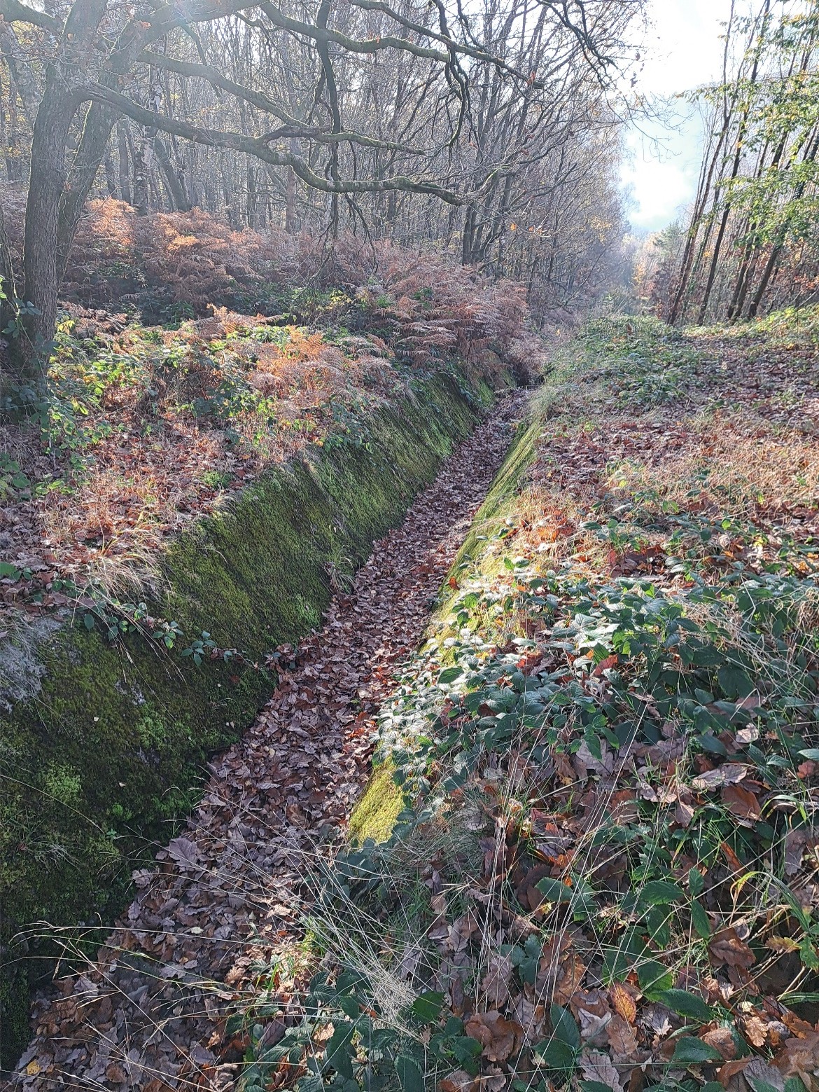
8.4.2 Locating old or inactive springs – no regret, soft adaptation
Using historic maps, identify locations where coal tips were established on or near natural springs. Due to alterations in the water table during coal extraction activities, these springs may have been inactive or diverted for extended periods. However, as rainfall patterns shift or natural hydrological recovery occurs, springs could re-emerge which could have an influence on tip stability[31]. Mapping the relationship between disused coal tips and spring locations allows for more targeted inspections and may highlight priority areas for installing new monitoring equipment. The National Library of Scotland holds an online archive of historic maps and plans covering all of Wales and includes Ordnance Survey sheets from the 1800 to the present day. It is worth noting that spring features shown on some older maps are not consistently present across all plans of the same locations, highlighting the importance of reviewing multiple documents. There may be an opportunity to harness the potential of artificial intelligence (AI) to assist with this task.
9. Recommendation
Conduct a review of historical maps and plans to identify tips that have been constructed on or in close proximity to former springs or natural well sites.
Purpose
This will enable the targeted monitoring of those tips for potential changes associated with renewed spring activity.
Action
Welsh Government Coal Tip Safety Task Force /MRA as extension to inspections
8.4.3 Construction materials – low regret, hard adaptation
When upgrading or installing new drainage systems on tip sites, it is important to incorporate enhanced capacity and use more robust materials. Construction methods and materials should be selected with consideration for rising temperatures and the increasing frequency of both drought and intense rainfall events. This approach aligns with the Build Back Better principle and helps ensure the system is resilient and future-proof. NRW has produced guidance on planning for extreme rainfall events in Wales, which should be consulted during scheme design[52]. The Construction Industry Research and Information Association (CIRIA) publishes a range of guides, manuals, and codes of practice that can inform both design decisions and material specification[53],[54].
8.4.4 Instrumentation – low regret, hard adaptation
At tips where multiple vulnerabilities have been identified following site visits and/or desk studies, the installation of monitoring equipment may be advisable. This could include instruments such as inclinometers and piezometers. These devices should be monitored alongside local rainfall data to determine whether any observed changes in ground conditions correlate with precipitation patterns. It is essential that monitoring is carried out in conjunction with a predefined action plan, ensuring that any significant rate of change is met with an appropriate and timely response.
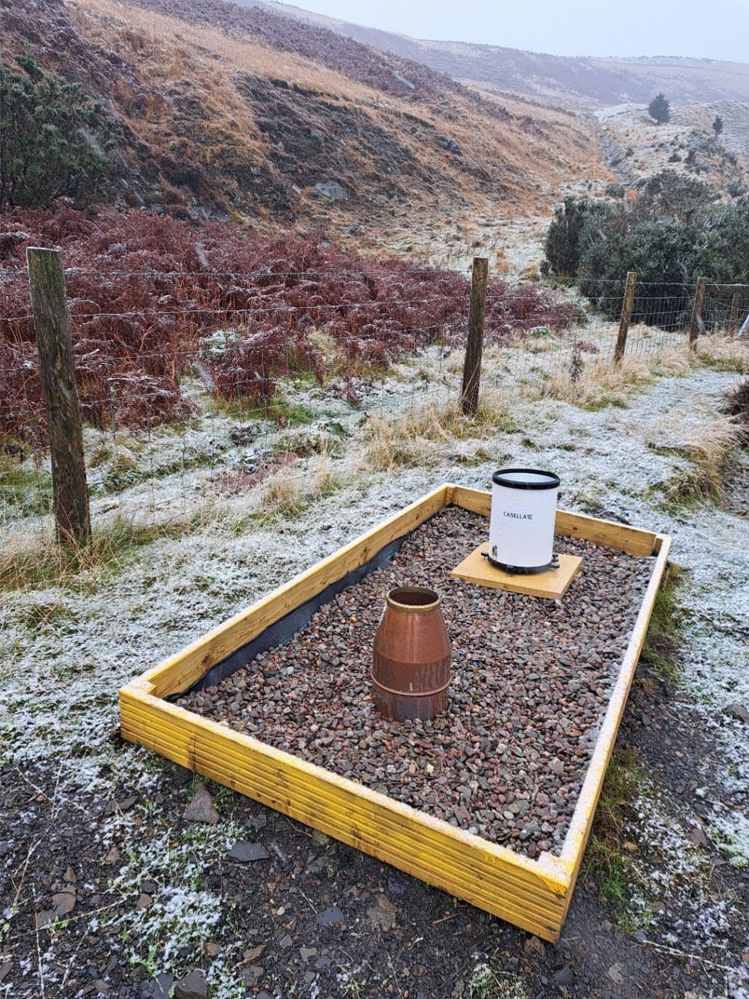
Recent advancements in artificial intelligence (AI) have been applied in Cardiff to pilot the use of CCTV monitoring for highway culverts, enabling real-time alerts to staff when screens become blocked[55]. This technology could be employed to monitor key screens on disused coal tips and prioritise site attendance.
8.4.5 Water balance of a site – low regret, soft adaptation
Where a disused tip is dominated by monoculture tree cover, consideration must be given to the medium and long-term hydrological management of the site. Mature conifers, for example, can use over 500 litres of water per day in evapotranspiration, significantly influencing the local water balance[56]. When the time comes to harvest the crop, this balance will shift dramatically. Post-felling, the tip’s hydrological response may differ substantially from pre-harvest conditions, potentially increasing the risk of erosion, flooding, and pollution[57]. Proactive measures should therefore be taken to mitigate these risks and ensure the site remains stable and environmentally secure.
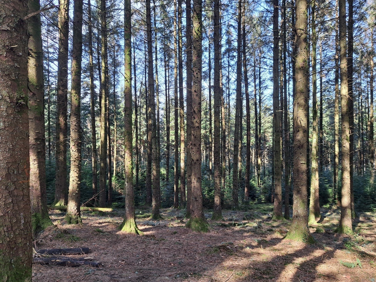
Image showing disused coal tip covered in mature conifers. Note limited ‘understory’ or vegetation cover at ground level.
Where conditions allow, the adoption of continuous cover forestry could be considered. This approach promotes the use of mixed-species planting with trees that mature at different rates. Instead of relying on clear-felling, continuous cover forestry involves the selective harvesting and replacement of individual trees, maintaining continuous canopy cover. This method offers significant benefits for habitat provision, soil conservation, and maintaining a stable water balance[58],[59].
8.4.6 Proactive clearance of screens – no regret, soft adaptation
When alerted to an approaching heavy rain event, it is sensible to proactively check debris screens and remove any litter or debris near drainage infrastructure. Ensuring these assets are clear before the rain arrives will help them function effectively during the storm. Tip owners should be familiar with the Daily Hazard Assessment alerts relating to landslide conditions issued by the British Geological Survey (BGS) as part of the Natural Hazards Partnerships[60].
At sites with engineered lagoons, proactively lowering water levels to create additional storage capacity could be an effective way to retain flood flows during predicted heavy rainfall.
8.4.7 Changes to planning consultation and categorisation of tips – low regret, soft adaptation
Under the current planning consultation framework, the Coal Authority trading as the Mining Remediation Authority (MRA) is a statutory consultee for certain planning applications within the defined coalfield polygons. However, it has a specific remit that focuses on only subsurface coal mining risks that could impact the stability of the proposed development or land use. This does not include or have any consideration of development that could impact disused coal tips.
Local authorities may have some awareness of the potential impact that development may have on coal tip safety but there isn’t a consistent defined process for consideration of developments that could adversely affect the stability, access, or monitoring of nearby tip sites. In order to avoid the most preventable cause of slope instability - the removal of material from the toe[31], planners need to be aware of the hazards of development near to disused coal tips.
Disused coal tips are currently classified into categories A to D, based on a range of risk factors. If a proposed development does increase the exposure of communities or infrastructure to a tip, its classification should be reviewed and updated to reflect the heightened risk. Similarly, if land use above the tip changes in such a way as to increase the vulnerability of the site to slope stability issues, the site category should be reviewed.
10. Recommendation
When the Disused Tips Authority be created, it should be a consultee for all developments within a defined area where tips are present.
Purpose
This would enable the authority to comment on proposals and ensure that any future development does not impact on the function, access or stability of a disused tip.
Action
Disused Tips Authority for Wales.
8.4.8 Application process for grant funding – no regret, soft adaptation
All documentation related to coal tip funding applications must explicitly reference climate change resilience. As part of the approval process, each proposal should include an assessment of the current and future climate vulnerability of the site and outline potential measures to reduce associated risks. A documented record of all mitigation options considered, along with a summary of those dismissed and the rationale for their exclusion. Funding should also only be granted if the applicant can demonstrate that there would be no outstanding safety issues from any previous tip inspection report.
11. Recommendation
All tips currently listed on the register should undergo periodic review to ensure their assigned risk category remains accurate and appropriate. As part of this process, there should be a formal mechanism to assess whether any changes, such as upslope modifications or downstream development, have altered the tip’s vulnerability or exposure. This assessment could be integrated into the routine tip inspection form or conducted as a separate desk-based review.
Purpose
To ensure that each tip is inspected in accordance with current site conditions and associated risks.
Action
Welsh Government Coal Tip Safety Task Force / Disused Tips Authority for Wales
12. Recommendation
The standard form for applicants to apply for grant funding should be altered to include mandatory climate change consideration and compliance with inspection recommendations. This should include an overview of any climate related adaptation measures that are proposed and outline what others were considered and discounted.
Purpose
To ensure that climate change considerations are recorded and evaluated and outstanding safety issues are addressed.
Action
Welsh Government Coal Tip Safety Task Force
8.4.9 Scheduling of Category C inspections – no regret, soft adaptation
Under the current inspection arrangement, Category D tips, those with the highest risk rating, are inspected twice a year. This enables experienced personnel to assess the site in two different seasons, helping to identify changes influenced by seasonal weather. A winter or early spring inspection allows for better visibility due to reduced vegetation and captures conditions following typically higher rainfall. A summer or early autumn visit may reveal signs of desiccation, warmer-weather impacts such as anti-social behaviour, and spring related water flows that might be hidden during wetter months.
In addition to observing the disused tip site across different seasons, inspections also provide an opportunity to assess upslope, downslope and neighbouring land for factors that could influence tip management or safety. These may include land use change such as planting or felling or the emergence of ecological or social opportunities that could be harnessed to support site resilience and deliver local benefits, such as improved biodiversity, community access, or educational use.
Category C tips are inspected once a year. If the timing of this annual inspection remains fixed, it may miss periods when the site is most vulnerable to weather-related impacts. This could also limit opportunities to identify potential local benefits or improvements.
13. Recommendation
Schedule inspections of Category C tips to rotate their inspection timing to cover different months. This would help ensure that inspections capture seasonal variations, such as dry and wet periods and times of reduced vegetative cover.
Purpose
To reduce the risk of missing weather-related vulnerabilities or opportunities for local benefit.
Action
Welsh Government Coal Tip Safety Task Force / Disused Tips Authority for Wales.
9.0 Implementation, communication, evaluation and reporting of measures
Evaluation and monitoring of climate change adaptation are essential to ensure that adaptation efforts are effective, responsive, and sustainable over time. They help measure whether actions are achieving their intended goals, such as reducing vulnerability or enhancing resilience, and provide critical data to inform decision-making and adjust strategies as conditions evolve. Monitoring also ensures accountability, supports learning from past experiences, and allows for flexible responses to emerging climate risks. The key steps in this process include defining clear objectives and measurable indicators, establishing baseline data, developing a structured monitoring plan, collecting and analysing relevant data, evaluating outcomes, communicating findings to stakeholders, and using the insights gained to refine and improve adaptation strategies. This continuous cycle of assessment and adjustment is vital for building long-term climate resilience.
Sharing both the successes and challenges of adaptation measures should be actively encouraged among tip owners and inspection authorities. Capturing lessons learned is essential to ensure that best practices are regularly reviewed, updated, and circulated.
Given that disused coal tips were specifically referenced in the CCRA3, it is likely that progress reports will be required to inform and update the process for future iterations of the assessment.
10. Opportunities
Climate change is expected to increase the complexity of managing coal tips, but it also presents opportunities for more sustainable and resilient land use. Mitigation and adaptation strategies can work hand in hand, for instance, new wetlands can both store carbon and reduce flood risk, while trees and other plants can help stabilise slopes and absorb carbon dioxide. Land managed for climate resilience often delivers multiple co-benefits, aligning with goals such as biodiversity enhancements, rewilding, nature recovery, and public access to green spaces. These approaches could support habitat restoration, enhance ecosystem services, and improve public health and wellbeing. The installation of renewable energy systems, including photovoltaic (PV) generation may also be appropriate in some instances when considering the future land use.
The MRA has recently commissioned ecological surveys across its portfolio of disused tips to establish a baseline for nature provision. Site management plans will be developed to actively enhance ecological value, with follow-up surveys scheduled to monitor progress against defined targets.
One of the key challenges in delivering wider benefits during works on disused coal tips is the limited space typically available. In many cases, land ownership extends only slightly beyond the tip itself, leaving little room for implementing desired improvements. For example, while attenuation ponds offer multiple benefits, such as ecological habitat creation, temporary floodwater storage, and landscape enhancement, they often cannot be accommodated within the existing site boundaries.
Efforts to manage rainwater efficiently on disused tips may sometimes conflict with broader catchment policies, such as sustainable drainage systems (SuDs). These efforts are aimed at slowing water flow to reduce urban flood risk during extreme rainfall. In Wales, certain developments must comply with the requirements of the SuDS Approval Body (SAB), which oversees drainage standards.
14. Recommendation
Discussions should be held with SAB decision-makers to explore whether flood retention features can be located outside the red line boundary of tip improvement schemes, provided they remain within the same catchment and upstream of known flood risk areas.
Purpose
If this approach were routinely permitted, it could enable off-site provision that supports multi-benefit land use—potentially delivering some of the health, wellbeing, and environmental outcomes identified by Welsh Government. This would be particularly effective if funding could be drawn from multiple sources, including the coal tip safety fund.
Action
Welsh Government Coal Tip Safety Task Force
Multi-agency collaboration involving public authorities, private organisations, and the charity sector can unlock cross-cutting benefits. With coordinated effort, parcels of currently disused or liability land could be repurposed and integrated to deliver the off-site flood storage required to offset the drainage improvements made within the tip boundary. With enough land, it could be possible to establish wet woodland, create connected community green spaces, and develop wildlife corridors. This approach might also be suitable for realising the biodiversity benefits required when undertaking developments works[62].
There is strong evidence that access to quality green space improves health and wellbeing outcomes[63], and Public Health Wales has programmes and partnerships to promote better provision particularly for disadvantaged urban communities
As former coalfield communities in Wales are often located in areas of socio-economic deprivation[63], there is significant potential to deliver wider benefits through the enhancement of disused coal tips. Established institutions are already working in partnership with others to secure funding and deliver improvements that support both environmental and community outcomes[64],[65]. Early and consistent engagement with communities is essential to delivering meaningful and lasting benefits. Involving local people from the outset helps build trust, ensures relevance, and fosters long-term ownership and sustainability of projects[66].
11. Conclusions
Climate change impacts in Wales are intensifying, with increasing frequency and severity of extreme weather events creating additional challenges to the management of disused coal tips. These legacy structures require targeted adaptation strategies due to their varied ownership, management practices, and exposure to climate hazards. However, efforts to enhance resilience are hindered by persistent data gaps and inconsistencies in monitoring, particularly across privately owned sites. While policy and governance frameworks are evolving, most notably through the proposed Disused Tips Authority, further integration of climate considerations into disused tip management, future planning and oversight is essential. Given the unique topographical and geological characteristics of each tip, adaptation measures must be site-specific, combining both soft and hard approaches. Importantly, climate adaptation also presents opportunities for co-benefits, including biodiversity enhancement, sustainable land use, and improved public engagement.
12. Next Steps
The next steps involve a dual responsibility. For the relevant authorities, it is essential to deepen their understanding of the compound threats facing disused coal tips from climate change by delivering on the written recommendations and systematically comparing emerging risks against established baseline conditions. This will help identify where climate change is altering the frequency, intensity, or nature of hazards.
At the same time, tip owners are encouraged to proactively review and upgrade their assets by assessing the adaptation options presented in the accompanying table. These measures will support more resilient site management and ensure that both policy and practice evolve in line with the changing climate landscape.
13. Appendices
Appendix A – Policy and legislation
The UK’s climate change policy and scrutiny landscape involves a range of key players, each with distinct roles in shaping, implementing, and evaluating climate action. At the heart of this framework is the Climate Change Committee (CCC), an independent statutory body established under the Climate Change Act 2008. The CCC advises the UK, Welsh and Scottish governments on emissions targets and reports to Parliament on progress in reducing greenhouse gas emissions and adapting to climate impacts. It includes the Adaptation Sub-Committee, which specifically scrutinises the government’s adaptation strategies. The Department for Energy Security and Net Zero (DESNZ) leads on climate mitigation policy, while the Department for Environment, Food and Rural Affairs (Defra) oversees adaptation efforts. Parliament also plays a critical role through select committees, which examine government performance and hold it accountable.
Wales has developed a distinct set of climate change policies and legislation within the framework of the UK’s broader commitments, particularly since the Climate Change Act 2008. The key climate-related policies and legislative actions specific to Wales are:
- Climate Change Act 2008 (UK-wide, applies to Wales)
•Wales is legally bound by the UK’s net zero by 2050 target.
•The Act requires carbon budgets and regular reporting, which Wales contributes to through devolved powers
- Environment (Wales) Act 2016
•A cornerstone of Welsh climate legislation.
•Introduced a legal duty for Welsh Ministers to reduce emissions by at least 80% by 2050 (from 1990 levels).
•Enabled the setting of carbon budgets and interim targets.
•Established the Natural Resources Policy and the principle of sustainable management of natural resources (SMNR)
Net Zero Wales Carbon Budget 2 (2021–2025)
•Sets out how Wales will meet its second carbon budget.
•Focuses on:- Decarbonising transport and housing
- Boosting renewable energy
- Nature-based solutions
- Green skills and jobs
- Wales Climate Change Adaptation Plan
•Based on the UK Climate Change Risk Assessment.
•Aims to build resilience in sectors like health, infrastructure, agriculture, and biodiversity.
- Well-being of Future Generations (Wales) Act 2015
•Not climate-specific but highly influential.
•Requires public bodies to consider long-term sustainability and climate resilience in decision-making.
•Introduced the role of the Future Generations Commissioner for Wales.
- Climate Action Wales (2023–2025)
•A public engagement and policy platform.
•Promotes community action, education, and behavioural change to support net zero goals
Climate Change policy In UK
- Climate Change Act 2008 (Amended in 2019)
•Originally set a legally binding target of 80% emissions reduction by 2050 (from 1990 levels).
•Amended in 2019 to commit the UK to net zero greenhouse gas emissions by 2050, making it the first major economy to do so
- Carbon Budgets
•The Act introduced five-year carbon budgets, legally binding limits on the total amount of greenhouse gases the UK can emit.
•As of 2025, the UK is in its sixth carbon budget period (2033–2037), which includes emissions from international aviation and shipping for the first time
- Clean Growth Strategy (2017)
•Aimed to decarbonize the UK economy while promoting economic growth focusing on areas like energy efficiency, low-carbon transport, and renewable energy.
- Environment Act 2021
•Introduced legally binding targets on air quality, water, biodiversity, and waste.
•Established the Office for Environmental Protection (OEP) to hold the government accountable on environmental matters.
- Ten Point Plan for a Green Industrial Revolution (2020) –
•Outlined £12 billion of government investment in areas including Offshore wind, Hydrogen production, Electric vehicles, Carbon capture and storage (CCS) and Green finance.
- Net Zero Strategy: Build Back Greener (2021)
• Detailed how the UK would meet its net zero target by 2050 and included sector-specific plans for power, buildings, transport, industry, and natural resources.
- Energy Security Strategy (2022)
• A response to global energy market volatility emphasising nuclear power, offshore wind, and energy independence
Appendix B – Rainfall types
Rainfall can be broadly classified into two primary types: convective and frontal (or cyclonic) rainfall, each arising from distinct atmospheric processes. Convective rainfall occurs predominantly in tropical regions and during warm summer afternoons in temperate zones. It is initiated by intense solar heating of the Earth's surface, which causes the air above to rise rapidly. As this warm, moist air ascends, it cools and condenses to form cumulonimbus clouds, often resulting in short-lived but intense precipitation events, frequently accompanied by thunderstorms. In contrast, frontal rainfall is characteristic of mid-latitude regions where contrasting air masses converge. When a warm air mass meets a colder one, the lighter warm air is forced to rise over the denser cold air, leading to gradual cooling and condensation. This process forms widespread cloud cover, typically stratus or nimbostratus clouds, and produces precipitation that is more prolonged and less intense than convective rainfall. Frontal rainfall is commonly associated with low-pressure systems and weather fronts, and it can affect large geographic areas over extended periods. Understanding these mechanisms is essential for interpreting regional weather patterns and anticipating hydrological impacts.
Appendix C - UKCP18
The UK Climate Projections 2018 (UKCP18) provide a comprehensive and scientifically robust set of climate projections developed by the UK Met Office to support national and regional adaptation planning. Building on the earlier UKCP09 projections, UKCP18 incorporates updated climate modelling and observational data, including inputs from Natural Resources Wales (NRW) and Met Office stations across Wales, to deliver high-resolution projections for both land and marine environments. These projections cover a wide range of climate variables such as temperature, rainfall, humidity, cloud cover, and sea level rise[67]. UKCP18 includes global, European, and UK-specific datasets, with a particularly detailed 2.2 km resolution model for localised analysis within the UK. The projections are based on multiple greenhouse gas emissions scenarios, allowing users to explore different potential futures depending on global mitigation efforts. Timeframes extend throughout the 21st century, with sea level rise projections reaching as far as 2300. UKCP18 is widely used by government agencies, local authorities, infrastructure planners, and researchers to assess climate risks and inform adaptation strategies, including the UK Climate Change Risk Assessment (CCRA) and the National Adaptation Programme (NAP). The data and tools are publicly accessible via the UKCP website, offering maps, graphs, and downloadable datasets to support evidence-based decision-making[68].
There are multiple ways to access data derived from the UKCP18 climate projections. While future emissions scenario information is available through various online platforms, it is important to note that most of these sources are based on the same underlying UKCP18 datasets. The UKCP18 platform itself offers a range of products that can be used to generate tailored projections for specific locations or areas of interest. For example, bespoke sea level rise projections can be created for a particular harbour location. The high-resolution 2.2 km climate model is particularly valuable for assessing future climate conditions in urban environments. Additionally, the UKCP18 ‘Extremes’ product provides projections for maximum and minimum temperature and extreme rainfall values across the four meteorological seasons, under different emissions scenarios. However, it should be noted that these projections are based on 25 km grid squares, which can result in rainfall values that appear lower when compared to point measurements from individual rain gauges. The plot below shows a relatively low median value of 73mm. This value has regularly been exceeded at individual rain gauges during recent named storms.
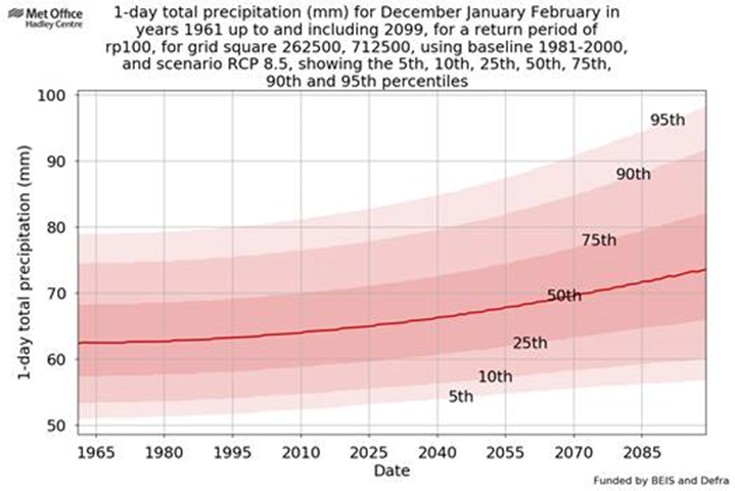
Appendix E - Climate change adaptation and assessment
ISO 14090:2019 is an international standard that establishes a framework for organizations to systematically integrate climate change adaptation into their governance, strategies, and operational activities. As the foundational document in a series of ISO standards on climate adaptation, it is designed to be universally applicable, regardless of an organization’s size, sector, or geographic location. The standard emphasizes the importance of building resilience by identifying climate-related risks and opportunities and incorporating them into decision-making processes. It outlines a structured approach that includes assessing climate impacts, planning appropriate adaptation measures, and implementing mechanisms for monitoring and continuous improvement. By promoting proactive and forward-looking strategies, ISO 14090:2019 supports organizations in enhancing their adaptive capacity and long-term sustainability in the face of climate variability and change.
ISO14091
- Preparing
- Assessing climate change
- Adaptation priorities
- Implementation
- Monitoring and evaluation
- Reporting and communication
The 8 steps of adaptation assessment
- Identify current and future climate hazards
- Conduct inventory of infrastructure and assets
- Characterize risk of climate change on infrastructure
- Develop initial adaptation strategies
- Identify opportunities for coordination
- Link strategies to capital and rehabilitation cycles
- Prepare and implement adaptation plans
- Monitor and reassess
The Task Force on Climate-related Financial Disclosures (TCFD) and ISO 14090 take complementary but distinct approaches to addressing climate change within organizations. TCFD is primarily focused on helping companies disclose climate-related financial risks and opportunities to stakeholders, particularly investors and regulators. It is structured around four key pillars—governance, strategy, risk management, and metrics and targets—and emphasizes the use of scenario analysis to assess financial resilience over short, medium, and long-term horizons. In contrast, ISO 14090 is an international standard designed to guide organizations in planning and implementing climate change adaptation strategies. It takes a more action-oriented approach, structured around understanding context, planning adaptation, and implementing actions to build long-term climate resilience. While TCFD is disclosure-driven and increasingly mandated in some jurisdictions, ISO 14090 is a voluntary framework that supports operational adaptation. In essence, TCFD helps organizations report how climate change affects their finances, whereas ISO 14090 helps them prepare for and adapt to those impacts.
References
1. What is climate change? - Met Office
2. Living better with a changing climate (publishing.service.gov.uk)
3. Europe is not prepared for rapidly growing climate risks | European Environment Agency's home page
4. Koe, A, Murphy, W, Parry, S, Daykin, A, Smith, J, Hart, A B, Battye, Natural slopes and landslides – condition, assessment and mitigation S CIRIA C807 © CIRIA 2023
5. D5.7 Landslides and Coal Tips | Public Health Wales
6. Lingfeng He et al Modelling the Control of Groundwater on the Development of Colliery Spoil Tip Failures in Wales. 2024
7. Written Statement: Update on Coal Tip Safety (11 February 2021) | GOV.WALES
8. Coal policy statement [HTML] | GOV.WALES
9. Coal tip safety | GOV.WALES
10. Climate Adaptation Strategy for Wales 2024
11. New legislation to address the safety issues caused by Wales’s mining past | GOV.WALES
12. The Disused Mine and Quarry Tips (Wales) Bill | GOV.WALES
13 Regulating coal tip safety in Wales – Law Commission
14. State of the UK Climate - Met Office
15. Wales: climate | Met Office
16. Coalfield H. J. Siddle, 1 M. D. Wright, 2 J. N. Hutchinson Rapid failures of colliery spoil heaps in the South Wales 3 Quarterly Journal of Engineering Geology and Hydrogeology, 1996
17. The CEDA Archive
18. River levels, rainfall and sea data
19. TUK Climate Risk Independent Assessment (CCRA3) Technical Report | UKCLIMATERISK.ORG
20. Evidence for the third UK Climate Change Risk Assessment (CCRA3) Summary for Wales | UKCLIMATERISK.ORG
21. Progress in adapting to climate change: 2025 report to Parliament - Climate Change Committee
22. Climate Change Risk Assessment Independent Assessment (CCRA4-IA) Technical Report - Met Office
24. Explore the Climate of your Local Authority
25. SPF City Pack editable template | METOFFICE.GOV.UK
26. 2023: Pioneering analysis projects extreme rainfall in UK | Cabot Institute for the Environment | University of Bristol
27. Quasi‐Stationary Intense Rainstorms Spread Across Europe Under Climate Change
28. Storms called Cut-off Lows are a Growing Climate Threat | Global Climate Risks
30. IPCC — Intergovernmental Panel on Climate Change
31. Practice, G.W, Handbook on the design of tip and related structures, DofE. HMSO 1991
32. RMW Musson. The Seismicity of Wales British Geological Survey 2005 Core.ac.uk
33. Landslides and rainfall | BGS.AC.UK
34. Effects of climate change - Met Office
35. Yuan-Chien Lin et al Strong wind is one of the important factors that trigger landslides,. 2025
36. Al-Ameeri, The effect of climate change on durability of existing concrete structures - The University of Brighton, 2019
37. How does climate change affect heatwaves? | Grantham Institute – Climate Change and the Environment | Imperial College London 2023
38. Climate change made severe UK fires in 2022 six times more likely - Met Office
39. Natural Resources Wales / The devastating consequences of wildfires in Wales
40. Parry, D and Chiverrell. Abandoned mine workings manual. CIRIA 2019
41. Rein, Guillermo. Personal email correspondence. Imperial College London. 2025
42. Sea level rise and coastal erosion: what’s the real impact? - British Geological Survey
43. Weather and behaviour | BPS
44. North Atlantic tipping point
45. Could the UK actually get colder with global warming? - BBC News
46. How does climate change affect thunderstorms? | Royal Meteorological Society
47. Met Office (2024): MIDAS Open: UK daily rainfall data, v202407. NERC EDS Centre for Environmental Data Analysis, 06 August 2024.
48. Climate change factsheet: Climate change and risks
49. Climate change in Wales - climatic variability and drought sensitivity - Forest Research
50. Fila.D, Funfgeld.H, Dahlmann.H Climate change adaptation with limited resources: adaptive capacity and action in small- and medium-sized municipalities. Environment, Development and Sustainability. 2023
51. Climate adaptation toolkit and risk generator
52. Adapting to Climate Change: Guidance for Flood and Coastal Erosion Risk Management Authorities in Wales
53. Good practice guide for managing climate change and extreme weather in land development: effective management of geo-based risks (C824D)
55. AI-trained CCTV in rivers can spot blockages and reduce floods
56. Forestry and Water Resources - Forest Research
57. Guidance for the use of silvicultural systems to increase woodland diversity
58. Regenerative forestry | SOILASSOCIATION.ORG
59. Adapting forests and woodlands in Wales to climate change - findings and recommendations | FORESTRESEARCH.GOV.UK
60. Daily Landslide Hazard Assessment - British Geological Survey.
61. National standards for sustainable drainage systems (SuDS) | GOV.WALES
62. Net Benefit for Biodiversity | The Wildlife Trust of South and West Wales
63. Championing nature for a healthy future – Public Health Wales’ Biodiversity Action Plan 2024-2027
64. Former coal mining communities have less faith in politics than other 'left behind' areas | University of Cambridge
65. Coalfields Regeneration Trust
66. What works: Community engagement and empowerment to address health inequalities - Health Equity Evidence Centre
67. UK Climate Projections (UKCP18) guidance and reports | Met Office
68. UKCP website