
Road lengths and conditions: April 2025 to March 2026
A report showing information by road class for April 2025 to March 2026.
In this page
Introduction
This release presents road length and conditions statistics for Wales covering the financial year 2025 to 2026 (a April 2025 to 31 March 2026). Data are also published on StatsWales: road.
Main points
The total road lengths in 2025 to 2026 was approximately 35,170km, a 0.1% increase compared to the previous financial year (2024 to 2025). Total road lengths in Wales change relatively little from year to year. The small increase in 2025 to 2026 was mainly due to the adoption of new roads and network reviews.
Powys contains the largest road network of the Welsh local authorities. It has the highest proportion of all trunk roads (27.3%), B and C roads (21.0%) and minor surfaced roads (12.0%) and accounts for 15.7% of the total road length of Wales.
In 2025 to 2026, 7.3% of the motorway network and 2.1% of the trunk road network required close monitoring of structural condition. This compares to 7.4% and 2.6% respectively in 2024 to 2025.
Figure 1: total road length by road classification, 2025-26 [Note 1]
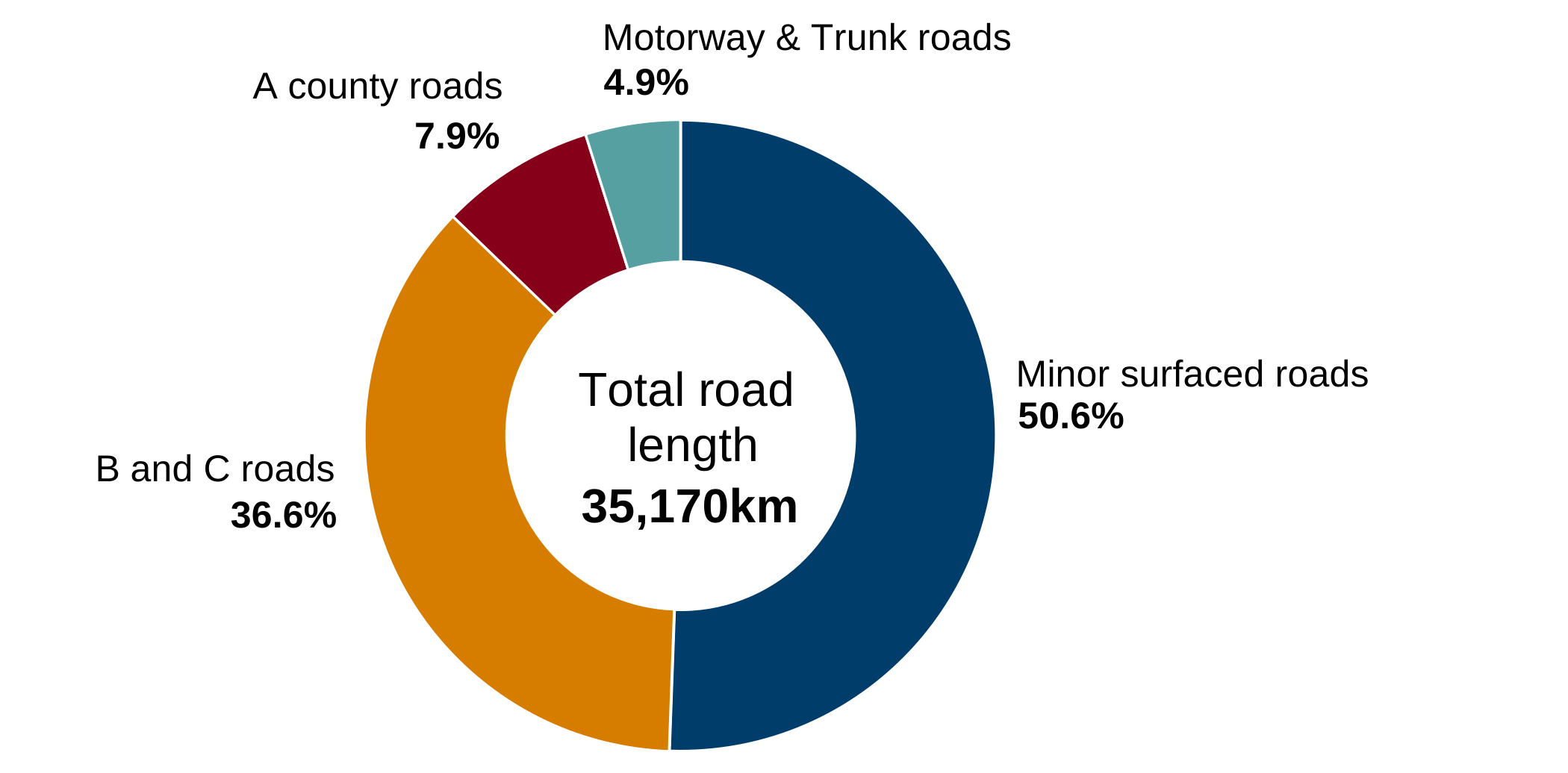
Description of figure 1: a doughnut chart showing breakdown of total road length by their road classification in 2025 to 2026 financial year. Most roads are Minor surfaced roads, followed by B and C roads.
Source: Road lengths and conditions statistics, Welsh Government
[Note 1] Percentages may not sum to 100% due to rounding.
Road lengths
The 6 classifications for surfaced roads are:
- motorways
- trunk roads
- A county roads
- B roads
- C roads
- minor surfaced roads
The Welsh Government is the highway authority for motorways and trunk roads. A county, B, C, and minor surfaced roads are the responsibility of local authorities.
Powys has the longest road network with 5,510 km (15.7%) of road, followed by Carmarthenshire with 3,690 km (10.5%). The bulk of the networks in these 2 authorities are minor roads (categories B, C and minor surfaced).
Newport has the longest stretch of motorway (26 km), representing 19.3% of the total motorway in Wales.
Please note, one local authority has not submitted data for the last 2 years. Given that their road lengths were unchanged for the 3 years before this, we have used their 2023 to 2024 data as an estimate for the latest 2 years. We are working with this local authority to collect the data and will update the figures when received.
Breakdowns by all local authorities in Wales are available on StatsWales.
Welsh Government managed roads
Structural condition of motorways and trunk roads
As of the end of March 2026, results from Deflectograph surveys (see the methodology section for more information) suggest the majority of the network was considered to be in good condition. It is estimated that 78.8% of the motorway and 88.7% of trunk roads will not be in need of close monitoring for at least 20 years.
This section deals with the condition of the road network, which is surveyed each year to determine its state of repair in terms of its structural condition. The survey showed that 7.3% of the motorway and 2.1% of the trunk road network is currently in need of close monitoring. The survey also showed that in the next 4 years, a further 2.6% of the motorway and 1.4% of trunk roads will need close monitoring.
One factor that affects the condition of roads is the volume of traffic. In 2025, road traffic estimates published by the Department for Transport, show that the traffic volume was 4.0 billion vehicle kilometres on the motorway, and 7.8 billion vehicle kilometres on trunk roads. This is the highest motorway and trunk road traffic on Welsh roads since comparable records began in 1993. Traffic per length of road is far higher on motorways when compared with trunk roads, county roads and minor roads.
More information on the volume of traffic on roads is available in the Road traffic statistical publication.
Figure 2: proportion of motorway and trunk roads requiring close monitoring of structural condition, 2022-23 to 2025-26 [Note 1]
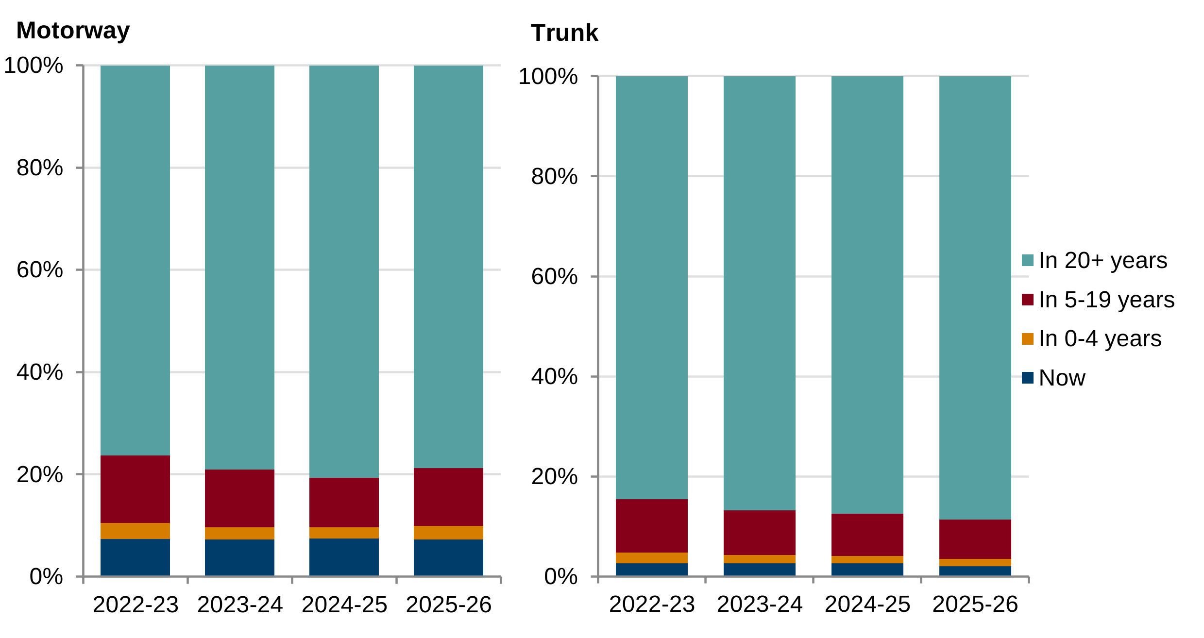
Description of figure 2: the stacked column chart shows the proportion of motorway and trunk roads that required close monitoring of their structural condition for each financial year; between 2022 to 2023 and 2025 to 2026.
Source: Road lengths and conditions statistics, Welsh Government
[Note 1] Based on results of Deflectograph surveys (see the methodology section for more information). The structural condition of a section of road needs close monitoring when it has a negative residual life. This excludes concrete pavements and elevated carriageways.
Skidding resistance of motorways and trunk roads
Skidding resistance relates to wet or damp road surfaces. It reflects the condition of the road surface by measuring resistance between vehicles’ tyres and the road when accelerating, breaking, or cornering. Testing takes place on wet surfaces as road surfaces exhibit least friction and skid resistance when wet. In 2025 to 2026, 99% of motorway surfaces and 93% of trunk road surfaces were surveyed.
The skidding resistance of the M4 is of a high standard, with only 0.4% of the surveyed surface found below investigatory level in 2025 to 2026. For the trunk road network, 10.5% of the surveyed surface was found to be at or below investigatory level in 2025 to 2026, the same as the previous year.
Note that these statistics are based on the results of SCRIM surveys (see the methodology section for more information). 'At or below investigatory level' does not mean the roads are unsafe; it indicates a need for further investigation to determine the need for maintenance of that section of road.
Road speed limit
The road length data included in this release is collected directly from local authorities. Road speed limit does not form part of this data collection. However, estimated road lengths by road speed limit in Wales as at September 2023 were published in September 2023. These estimates were produced by Welsh Government and Transport for Wales, using OS MasterMap Highways Speed Layer, the road lengths data that forms part of this statistical series and spatial data returns from Highway Authorities.
Local authority road conditions
Data on Local authority road conditions was previously collected as part of Public Accountability Measures (PAMs) led by Data Cymru. However this data is no longer collected.
Quality information
Relevance
The statistics are used both within and outside the Welsh Government to monitor trends in road lengths and conditions. They are also used in Standard Spending Assessment (SSA) calculations, which are used to distribute funding to local authorities.
Accuracy
More information can be found in the technical note published by the Department for Transport (DfT).
Timeliness and punctuality
The statistics on road lengths and conditions relate to data obtained for the financial year 2025 to 2026.
Accessibility and clarity
This statistical bulletin is pre-announced and then published on the Statistics for Wales website and is accompanied by tables on our StatsWales website: road.
Deflectograph surveys
There are 2 main methods of processing Deflectograph data. The Welsh Government made use of the Deflec method for all of surveys up to 2014 to 2015. Since 2015 to 2016, the Welsh Government has used the Pandef method of processing.
This results in a discontinuity in the data between 2014 to 2015 and 2015 to 2016. However, this change in software aligns the Welsh Government with the methods used by the rest of the UK, including Highways England and Transport Scotland.
Sideway-force Coefficient Routine Investigation Machine (SCRIM) surveys
As a result of the variation in skidding properties, until 2005, SCRIM surveys of the trunk road network were carried out on one third of the network each year. Each length was surveyed 3 times in the year (at the start, middle and end of the SCRIM survey season).
However, there was a change in approach to the surveying of trunk roads from 2005; skidding resistance measurements are now undertaken each year under a single annual survey regime. The surveys are scheduled so that, over a three-year period, the network is surveyed early, middle and late in the test season in successive years. This means a length that was surveyed early in the first year will be surveyed in the middle of the season in the second year and then late in the season in the third year.
Highways England (formerly the Highways Agency) has implemented an annual correlation trial for SCRIM survey vehicles, which are currently carried out by TRL (Transport Research Laboratory). All SCRIM vehicles undertaking surveys on trunk roads are required to pass the trial in order to undertake surveys on the trunk road network. Other SCRIM survey operators are also able to attend the trials, although it is not compulsory. However, local authorities commissioning SCRIM surveys typically expect that the SCRIM vehicles used on their network will have passed the trials, and therefore in practice it has been found that all SCRIM vehicles operating in the UK attend the trials. In the trials the SCRIM vehicles are required to undertake surveys on a number of sites having different levels of skid resistance and the data is compared to identify outliers. The trials therefore aim to ensure consistency across the fleet of vehicles operating in the UK.
Official statistics status
All official statistics should show the standards of the Code of Practice for Statistics (UK Statistics Authority).
These are accredited official statistics. Their designation was confirmed in February 2011 following a full assessment against the Code of Practice (UK Statistics Authority). They comply with the standards of trustworthiness, quality and value in the Code of Practice for Statistics.
It is Welsh Government’s responsibility to maintain compliance with the standards expected of accreditation. If we become concerned about whether these statistics are still meeting the appropriate standards, we will discuss any concerns with Office for Statistics Regulation (OSR) promptly. Accreditation can be cancelled or suspended at any point when the highest standards are not maintained, and reinstated when standards are restored.
Accredited official statistics are called National Statistics in the Statistics and Registration Service Act 2007.
Statement of compliance with the Code of Practice for Statistics
Our statistical practice is regulated by the OSR. OSR sets the standards of trustworthiness, quality and value in the Code of Practice for Statistics that all producers of official statistics should adhere to.
All of our statistics are produced and published in accordance with a number of statements and protocols to enhance trustworthiness, quality and value. These are set out in the Welsh Government’s Statement of Compliance.
These accredited official statistics (OSR) demonstrate the standards expected around trustworthiness, quality and public value in the following ways.
Trustworthiness
The road length data is collected directly from local authorities and from departments that are directly involved with the management of the Welsh road network. Data on road conditions are from SCRIM surveys and are described in the Comparability and coherence section of this report.
These statistics are pre-announced on the Statistics and Research area of the Welsh Government website.
Access to the data during processing is restricted to those involved in the production of the statistics, quality assurance and for operational purposes. Pre-release access is restricted to eligible recipients in line with the Code of Practice for Statistics (UK Statistics Authority).
Quality
The published figures provided are compiled by professional analysts using the latest available data and applying methods using their professional judgement and analytical skillset. Statistics published by Welsh Government adhere to the Statistical Quality Management Strategy which supplements the Quality pillar of the Code of Practice for Statistics and the European Statistical System principles of quality for statistical outputs.
Validation checks are performed by Welsh Government statisticians and queries referred to local authorities where necessary. The statistical release is then drafted, signed off by senior statisticians and published in line with the statement on confidentiality and data access which is informed by the trustworthiness pillar contained in the Code of Practice for Statistics.
Value
The purposes of this statistical release and the accompanying data published on StatsWalesStatsWales are to provide evidence for policy development and to inform the media and wider public about the changes to the Welsh road network and its condition.
You are welcome to contact us directly with any comments about how we meet these standards. Alternatively, you can contact OSR by emailing regulation@statistics.gov.uk or via the OSR website.
Well-being of Future Generations Act (WFG)
The Well-being of Future Generations Act 2015 is about improving the social, economic, environmental and cultural wellbeing of Wales. The Act puts in place seven wellbeing goals for Wales. These are for a more equal, prosperous, resilient, healthier and globally responsible Wales, with cohesive communities and a vibrant culture and thriving Welsh language. Under section (10)(1) of the Act, the Welsh Ministers must (a) publish indicators (“national indicators”) that must be applied for the purpose of measuring progress towards the achievement of the wellbeing goals, and (b) lay a copy of the national indicators before Senedd Cymru. Under section 10(8) of the Well-being of Future Generations Act, where the Welsh Ministers revise the national indicators, they must as soon as reasonably practicable (a) publish the indicators as revised and (b) lay a copy of them before the Senedd. These national indicators were laid before the Senedd in 2021. The indicators laid on 14 December 2021 replace the set laid on 16 March 2016.
Information on the indicators, along with narratives for each of the well-being goals and associated technical information is available in the Wellbeing of Wales report.
Further information on the Well-being of Future Generations (Wales) Act 2015.
The statistics included in this release could also provide supporting narrative to the national indicators and be used by public services boards in relation to their local wellbeing assessments and local wellbeing plans.